Data
- Obtaining
- Supplying
- High-Frequency
- Bottom Pressure Records
- Other Long Records
- GLOSS/ODINAFRICA Calibration Data
Donate
Donate to PSMSL
Data Notes
- Individual Station Data and Plot Notes
- Referencing the Data Set
- PSMSL Help File
- 2010 Changes to the PSMSL Data Files
Extracted from Database
13 Jul 2026
Station Information
| Station ID: | 2287 |
| Latitude: | 20.0205 |
| Longitude: | -75.836667 |
| Coastline code: | 930 |
| Station code: | 85 |
| Country: | CUBA |
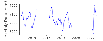
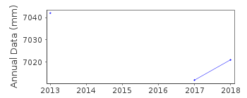
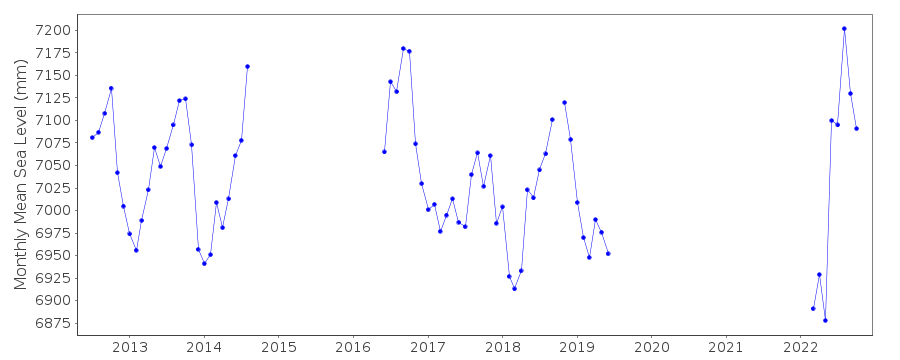
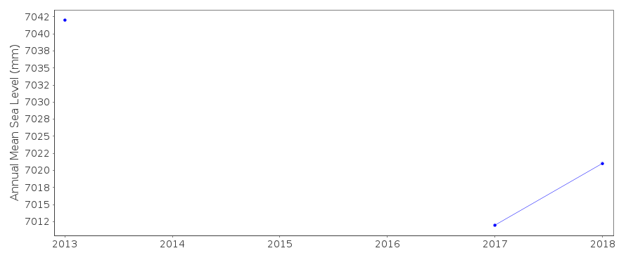
| Time span of data: | 2012 – 2022 |
| Completeness (%): | 53 |
| Date of last update: | 20 Sep 2023 |
| Green Arrow: | Current Station |
| Yellow Marker: | Neighbouring RLR Station |
| Red Marker: | Neighbouring Metric Station |
Please note: In many cases, the station position in our database is accurate to only one minute. Thus, the tide gauge may not appear to be on the coast.
Tide Gauge Data
Station Documentation
Link to RLR information.Documentation added 2016-04-28
Santiago de Cuba is a newly supplied Cuban station. Using information supplied by the Cuban National Tidal Service Santiago de Cuba has been made RLR. Primary benchmark is TGBM 010A 3.379m above Tide Gauge Zero and 1.849m above Geodesic National Datum (GND).Documentation added 2016-06-29
Information supplied by Cuba confirms that since 1992 the tide gauge sensor is a float recording hourly.Documentation added 2018-04-05
The tide gauge at Santiago de Cuba was damaged by a storm and destroyed by hurricane Sandy. Since 2016 Santiago de Cuba has been operating from a temporary station. Plans are for a new radar gauge to be installed during 2018.Data Authority
Cuban National Tidal ServiceCalle 4 No. 304, E/3 Y 3-a
Playa
Cuidad Habana

![]()
![]()
![]()
