Data
- Obtaining
- Supplying
- High-Frequency
- Bottom Pressure Records
- Other Long Records
- GLOSS/ODINAFRICA Calibration Data
Donate
Donate to PSMSL
Data Notes
- Individual Station Data and Plot Notes
- Referencing the Data Set
- PSMSL Help File
- 2010 Changes to the PSMSL Data Files
Extracted from Database
13 Jul 2026
Station Information
| Station ID: | 2338 |
| Latitude: | 43.321764 |
| Longitude: | -1.931514 |
| Coastline code: | 200 |
| Station code: | 2 |
| Country: | SPAIN |
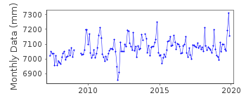
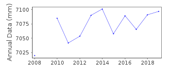
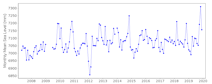
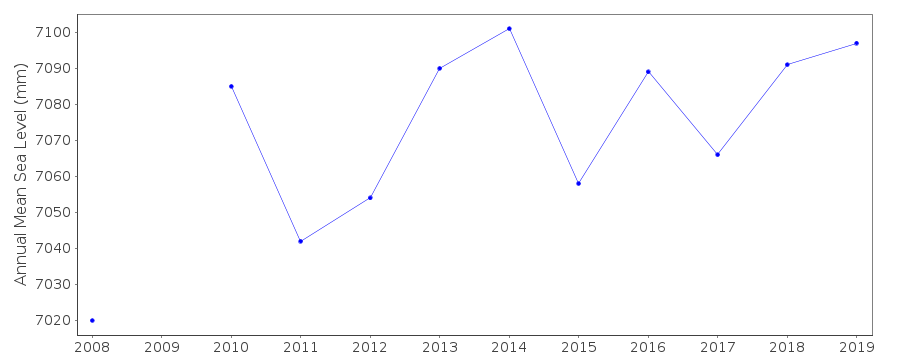
| Time span of data: | 2007 – 2025 |
| Completeness (%): | 84 |
| Link to ellipsoid: | Available |
| Date of last update: | 22 May 2026 |
| Green Arrow: | Current Station |
| Yellow Marker: | Neighbouring RLR Station |
| Red Marker: | Neighbouring Metric Station |
Please note: In many cases, the station position in our database is accurate to only one minute. Thus, the tide gauge may not appear to be on the coast.
Tide Gauge Data
Station Documentation
Link to RLR information.Documentation added 2018-10-09
Daily and monthly sea level data for Pasaia Harbour are supplied on a monthly basis by the GEOLAB Pasaia Team.Documentation added 2018-10-10
GEOLAB is an agreement between ARANZADI located in Zorrogagaina, 11. E-20014 Donostia, San Sebastian and AZTI located in Herrera Kaia, Portualdea z/g. E-20110, Pasaia (Gipuzkoa).Using information supplied by J. Zurutuza, on behalf of the GEOLAB Pasaia Team station Pasaia Harbour has been made RLR. Primary Benchmark TGBM-A is 7.061m above Tide Gauge Zero (TGZ)
Documentation added 2018-10-31
The Tide Gauge and GNSS devices for Pasaia Harbour are located in the AZTI facilities at Herrera Kaia.Documentation added 2026-05-07
The data were revised following a 2020 power outage that damaged the original pressure sensor and datalogger. Historical data from March 2007–January 2020 were corrected for an erroneous freshwater density setting that caused systematic sea level overestimation, while data from February 2020–October 2021 were excluded due to sensor malfunction and unreliable residuals. A new VEGAPULS C21 radar sensor has been in operation since November 2021.Data Authority
Department of Applied GeodesyZorrogagaina, 11
E-20014 Donostia
San Sebastian

![]()
![]()
![]()
