Data
- Obtaining
- Supplying
- High-Frequency
- Bottom Pressure Records
- Other Long Records
- GLOSS/ODINAFRICA Calibration Data
Donate
Donate to PSMSL
Data Notes
- Individual Station Data and Plot Notes
- Referencing the Data Set
- PSMSL Help File
- 2010 Changes to the PSMSL Data Files
Extracted from Database
13 Jul 2026
Station Information
| Station ID: | 2354 |
| Latitude: | 46.9168 |
| Longitude: | -55.3901 |
| Coastline code: | 970 |
| Station code: | 113 |
| Country: | CANADA |
| Time span of data: | 2006 – 2024 |
| Completeness (%): | 93 |
| Date of last update: | 19 Jun 2025 |
| Green Arrow: | Current Station |
| Yellow Marker: | Neighbouring RLR Station |
| Red Marker: | Neighbouring Metric Station |
Please note: In many cases, the station position in our database is accurate to only one minute. Thus, the tide gauge may not appear to be on the coast.
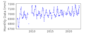
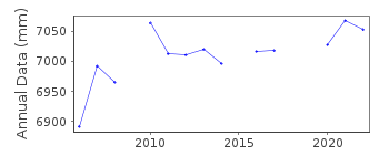
Tide Gauge Data
Station Documentation
Link to RLR information.Documentation added 2018-11-13
St. Lawrence is a new station on the Burin Peninsula.Documentation added 2019-06-18
Atlantic station St. Lawrence - a contractor tore the entire gauge off the wharf. Electronics and infrastructure were damaged beyond repair. The whole gauge had to be rebuilt. It has been back in operation again since March 2019.Data Authority
Canadian Hydrographic Service615 Booth Street
Ottawa
Ontario K1A 0E6

![]()
![]()
![]()
