Data
- Obtaining
- Supplying
- High-Frequency
- Bottom Pressure Records
- Other Long Records
- GLOSS/ODINAFRICA Calibration Data
Donate
Donate to PSMSL
Data Notes
- Individual Station Data and Plot Notes
- Referencing the Data Set
- PSMSL Help File
- 2010 Changes to the PSMSL Data Files
Extracted from Database
20 Jul 2026
Station Information
| Station ID: | 248 |
| Latitude: | 1.461667 |
| Longitude: | 103.791667 |
| Coastline code: | 550 |
| Station code: | 11 |
| Country: | MALAYSIA |
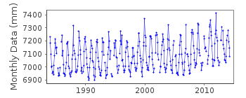
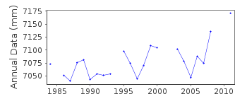
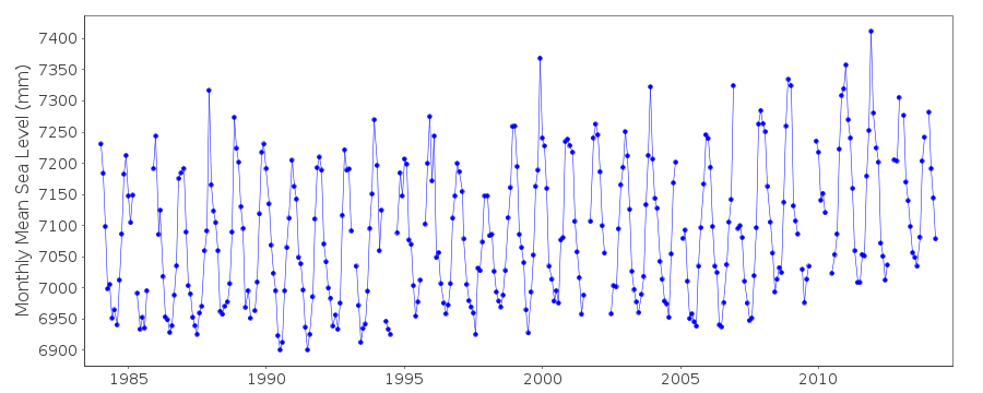
| Time span of RLR data: | 1984 – 2014 |
| RLR completeness (%): | 91 |
| Time span of metric data: | 1923 – 2014 |
| Metric completeness (%): | 33 |
| Date of last update: | 04 May 2017 |
| Green Arrow: | Current Station |
| Yellow Marker: | Neighbouring RLR Station |
| Red Marker: | Neighbouring Metric Station |
Please note: In many cases, the station position in our database is accurate to only one minute. Thus, the tide gauge may not appear to be on the coast.
Tide Gauge Data
Additional Data Sources (guide to additional data sources)
Research Quality Data from UHSLC station 321: hourly and dailyStation Documentation
Link to RLR information.Documentation - date unknown
1923-1924, 1929-1930 DATA SUPPLIED BY AUTHORITY NO. 10 AND BASED ON24 READINGS PER DAY
Documentation added 1993-07-12
Johor Bahru 550/011 RLR(1987) is 10.3m below BM No. J0416Documentation added 2017-05-04
This station has now been decommissioned due to rapid development in the area.Data Authority
Department of Survey and MappingWisma JUPEM
Jalan Semarak
50578 Kuala Lumpur

![]()
![]()
![]()
