Data
- Obtaining
- Supplying
- High-Frequency
- Bottom Pressure Records
- Other Long Records
- GLOSS/ODINAFRICA Calibration Data
Donate
Donate to PSMSL
Data Notes
- Individual Station Data and Plot Notes
- Referencing the Data Set
- PSMSL Help File
- 2010 Changes to the PSMSL Data Files
Extracted from Database
13 Jul 2026
Station Information
| Station ID: | 317 |
| Latitude: | 42.483333 |
| Longitude: | 27.483333 |
| Coastline code: | 295 |
| Station code: | 21 |
| Country: | BULGARIA |
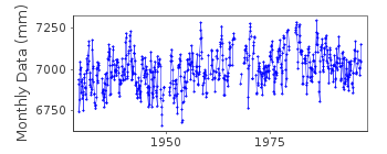
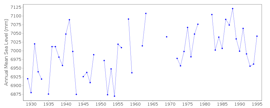
| Time span of RLR data: | 1929 – 1996 |
| RLR completeness (%): | 86 |
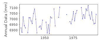
| Time span of metric data: | 1928 – 1996 |
| Metric completeness (%): | 85 |
| Date of last update: | 27 Aug 1997 |
| Green Arrow: | Current Station |
| Yellow Marker: | Neighbouring RLR Station |
| Red Marker: | Neighbouring Metric Station |
Please note: In many cases, the station position in our database is accurate to only one minute. Thus, the tide gauge may not appear to be on the coast.
Tide Gauge Data
Station Documentation
Link to RLR information.Documentation added 1997-08-27
The site of the tide gauge is subject to subsidence. During the period 1929-95 the datum of observations has sunk 0.244mDocumentation added 1999-03-10
For a discussion on sea level trends along Black Sea coasts see Variations of the Black Sea Level by S.G.Boguslavsky et al., Physical Oceanography, 9(3), 199-208, 1998.Documentation added 1999-03-10
Bulgarian sea levels likely to be heavily influenced by river flow.Documentation added 1999-03-10
In March 1999 a 'buddy checking' on the following 6 Black Sea stations in the RLR data set in order to check out some apparent west-east differences in the MSL values:295021R Bourgas Bulgaria
295051R Varna ..
297021R Constantza Romania
300001R Tuapse Russia
305021R Poti Georgia
305031R Batumi ..
It seems that Varna, Tuapse and Batumi seem basically 'ok' except that after about 1985 Tuapse and Batumi start to increase relative to Varna. The increase of Tuapse is about 10 cm relative to the western ones, that of Batumi is more like 20. Bourgas compared to Varna seems 'ok' as well except there is a period around 1950-55 when Bourgas is relatively low by about 8 cm. Also Constantza is ok relative to Varna if a large dip in Constantza around 1980-85 and a datum shift around 1948 are taken out. Tuapse minus Constantza shows the rise from about 1985 again. For Poti, it is very hard to see what is going on given the large background trend. It has a clear large fall in 1960's though. real? And as Tuapse and Batumi have different increases relative to the west presumably the effect is in the east? Are there levelling (datum) concerns we are not aware of? Recent changes to local rivers?
Documentation added 2000-01-25
Bourgas 295/021 RLR(1995) is 11.5m below BM no. 12Bourgas is an historic station last data 1996.
Data Authority
Min. of Regional Dev. and ConstructionResearch Institute of Geodesy and Photogrammetry
1 Moussala Str.
1618 Sofia

![]()
![]()
![]()
