Data
- Obtaining
- Supplying
- High-Frequency
- Bottom Pressure Records
- Other Long Records
- GLOSS/ODINAFRICA Calibration Data
Donate
Donate to PSMSL
Data Notes
- Individual Station Data and Plot Notes
- Referencing the Data Set
- PSMSL Help File
- 2010 Changes to the PSMSL Data Files
Extracted from Database
13 Jul 2026
Station Information
| Station ID: | 323 |
| Latitude: | 55.583333 |
| Longitude: | 12.933333 |
| Coastline code: | 50 |
| Station code: | 61 |
| Country: | SWEDEN |
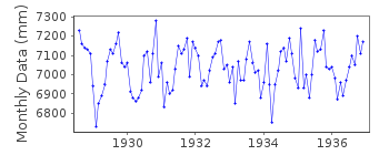
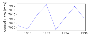
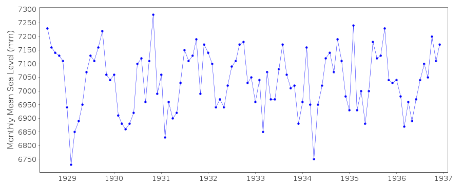
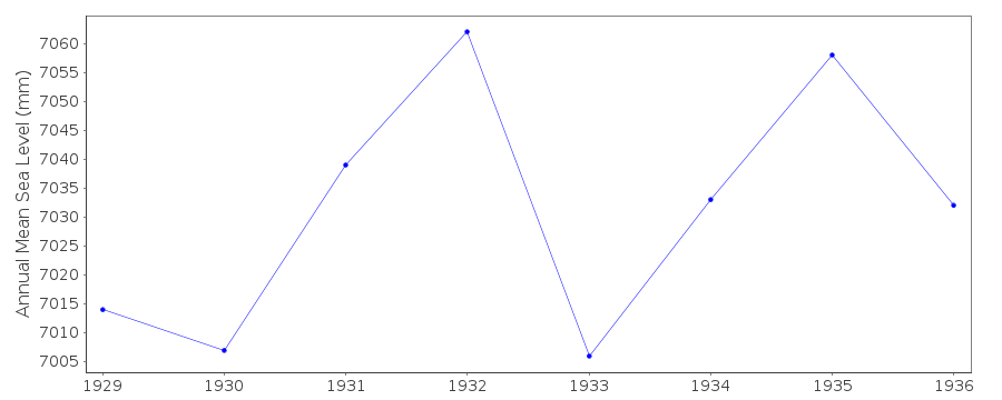
| Time span of data: | 1928 – 1936 |
| Completeness (%): | 94 |
| Date of last update: | 01 Jan 1980 |
| Green Arrow: | Current Station |
| Yellow Marker: | Neighbouring RLR Station |
| Red Marker: | Neighbouring Metric Station |
Please note: In many cases, the station position in our database is accurate to only one minute. Thus, the tide gauge may not appear to be on the coast.
Tide Gauge Data
Additional Data Sources (guide to additional data sources)
Nearby GNSS Stations from SONEL: 1MALNearby Real Time Stations from VLIZ: maha, klag
Station Documentation
Link to RLR information.Documentation added 1991-06-11
Limhamn 050/061 RLR(1936) is 10.5m below BM No fix 1Documentation added 1993-07-12
Limhamn 050/061 RLR(1936) is 10.5m below BM No fix 1Data Authority
Swedish Met. and Hyd. InstituteBox 923
S601 76 Norrkoping

![]()
![]()
![]()
