Data
- Obtaining
- Supplying
- High-Frequency
- Bottom Pressure Records
- Other Long Records
- GLOSS/ODINAFRICA Calibration Data
Donate
Donate to PSMSL
Data Notes
- Individual Station Data and Plot Notes
- Referencing the Data Set
- PSMSL Help File
- 2010 Changes to the PSMSL Data Files
Extracted from Database
20 Jul 2026
Station Information
| Station ID: | 352 |
| Latitude: | 43.5067 |
| Longitude: | 16.4417 |
| Coastline code: | 280 |
| Station code: | 31 |
| Country: | CROATIA |
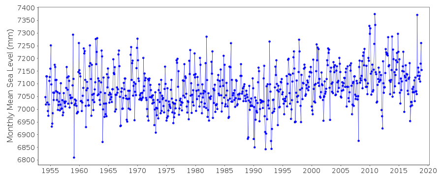
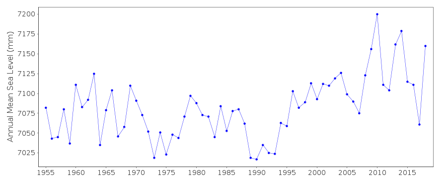
| Time span of RLR data: | 1954 – 2018 |
| RLR completeness (%): | 100 |
| Time span of metric data: | 1930 – 2018 |
| Metric completeness (%): | 87 |
| Link to ellipsoid: | Available |
| Date of last update: | 11 Jul 2019 |
| Green Arrow: | Current Station |
| Yellow Marker: | Neighbouring RLR Station |
| Red Marker: | Neighbouring Metric Station |
Please note: In many cases, the station position in our database is accurate to only one minute. Thus, the tide gauge may not appear to be on the coast.
Tide Gauge Data
Station Documentation
Link to RLR information.Documentation added 1991-06-11
Split Harbour 280/031 RLR(1964) is 10.4m below BMNo165Documentation added 1992-03-04
Prior to 1990 data from Hidrografski Institut, SplitDocumentation added 1996-01-12
Tide gauge of the State Hydrographic Institute at SplitDocumentation added 1996-01-12
Gauge=A. Ott, KemptenDocumentation added 1997-11-06
Split data have different datum levels either side of World War II precluding the construction of a continuous RLR time series.Documentation added 2011-01-20
No benchmark information for very early data. Very little for data for 1954. Station information sheet recently supplied refers to the gauge being operational from 1955 omwards. Primary benchmark is PN 165 3.9232m above TGZ. Benchmark R1 is 3.5051m above TGZ. RLR factor 1955 onwards is 6.477m.Documentation added 2019-07-16
When the 2018 data is plotted there is evidence of a surge in March 2018.Data Authority
Hidrografski Institut of Rep. of CroatiaZrinsko-Frankopanska 161
21000 Split

![]()
![]()
![]()
