Data
- Obtaining
- Supplying
- High-Frequency
- Bottom Pressure Records
- Other Long Records
- GLOSS/ODINAFRICA Calibration Data
Donate
Donate to PSMSL
Data Notes
- Individual Station Data and Plot Notes
- Referencing the Data Set
- PSMSL Help File
- 2010 Changes to the PSMSL Data Files
Extracted from Database
13 Jul 2026
Station Information
| Station ID: | 393 |
| Latitude: | 47.566667 |
| Longitude: | -52.716667 |
| GLOSS ID: | 223 |
| Coastline code: | 970 |
| Station code: | 121 |
| Country: | CANADA |
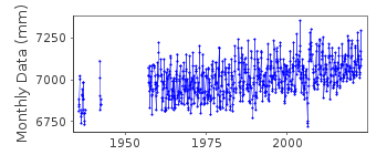
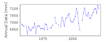
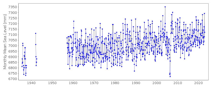
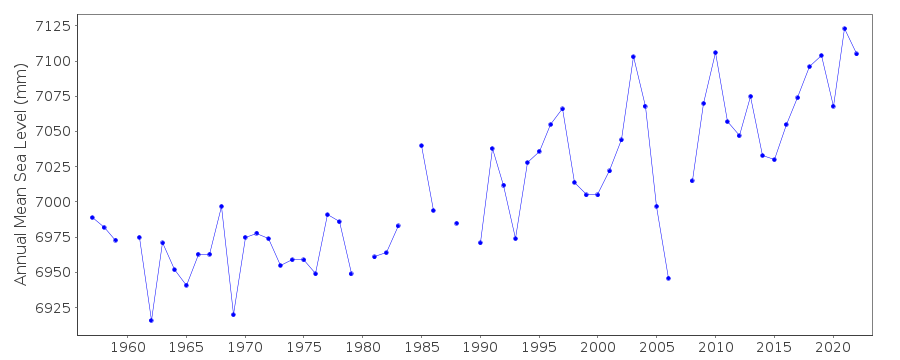
| Time span of data: | 1935 – 2024 |
| Completeness (%): | 76 |
| Link to ellipsoid: | Available |
| Date of last update: | 19 Jun 2025 |
| Green Arrow: | Current Station |
| Yellow Marker: | Neighbouring RLR Station |
| Red Marker: | Neighbouring Metric Station |
Please note: In many cases, the station position in our database is accurate to only one minute. Thus, the tide gauge may not appear to be on the coast.
Tide Gauge Data
Additional Data Sources (guide to additional data sources)
Nearby GNSS Stations from SONEL: STJ3, STJONearby Real Time Stations from VLIZ: stjo
Fast Delivery Data from UHSLC station 276: hourly and daily
Research Quality Data from UHSLC station 276: hourly and daily
Station Documentation
Link to RLR information.Documentation added 1994-03-23
data up to 1992 revised, March 1994Documentation added 1994-07-15
St John's 970/121 RLR(1992) is 10.0m below BM 90F9000Documentation added 1997-09-24
Station moved to a new site within St. John's harbour during 1990Documentation added 2006-12-05
Revised historical data 1935-7, 1942 supplied 17th April 2001. This was confirmed to be the same datum as 1957-Documentation added 2008-03-06
Data 2004 flagged suspect. However, when buddy checked with 2 local stations the dip is apparent in these also. The flagging has been removed.Documentation added 2011-08-18
Using data from the Canadian Hydrographic service the RLR diagram has been re-drawn. Primary benchmark remains 90F9000 at 3.808m above Chart Datum. Benchmark 76-F-727 is also still in use.Documentation added 2015-07-27
This year, rather than just sending the latest year of data, the complete dataset has been supplied. This has highlighted some differences in the data. From communications in the correspondence file for 2002 it appears that the Oceans and Fisheries meant to supply revised data for the stations supplied. This did not happen. The complete dataset includes these data revisions. Therefore, the whole dataset has now been re-entered.Documentation added 2015-07-30
Historic data was included in the above complete dataset. The datum for the period 1935-1942 is currently being queried. Until the Fisheries and Oceans Canada confirm the datum this data has been made Metric.Documentation added 2016-06-28
It has been confirmed by the Canadian Authority that the datum for the historic data for 1935-1942 is CD as the rest of the data. The historic data has been added to the RLR data. However, the 1935-1937 data was 'corrected to zero of the diagram' and 1.29ft subtracted from the data to convert it to CDDocumentation added 2017-06-29
Data for 2012-2015 updated for Canadian Atlantic network. The supplier provided a finalised version following a review by the regional office.Data Authority
Canadian Hydrographic Service615 Booth Street
Ottawa
Ontario K1A 0E6

![]()
![]()
![]()
