Data
- Obtaining
- Supplying
- High-Frequency
- Bottom Pressure Records
- Other Long Records
- GLOSS/ODINAFRICA Calibration Data
Donate
Donate to PSMSL
Data Notes
- Individual Station Data and Plot Notes
- Referencing the Data Set
- PSMSL Help File
- 2010 Changes to the PSMSL Data Files
Extracted from Database
13 Jul 2026
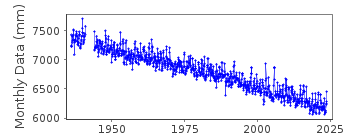
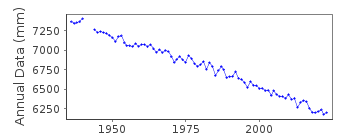
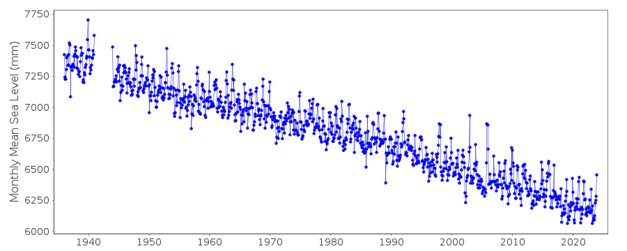
Station Information
| Station ID: | 405 |
| Latitude: | 58.298333 |
| Longitude: | -134.411667 |
| Coastline code: | 821 |
| Station code: | 44 |
| Country: | UNITED STATES |
| Time span of data: | 1936 – 2025 |
| Completeness (%): | 97 |
| Date of last update: | 28 Jan 2026 |
| Green Arrow: | Current Station |
| Yellow Marker: | Neighbouring RLR Station |
| Red Marker: | Neighbouring Metric Station |
Please note: In many cases, the station position in our database is accurate to only one minute. Thus, the tide gauge may not appear to be on the coast.
Tide Gauge Data
Additional Data Sources (guide to additional data sources)
Nearby GNSS Stations from SONEL: JNU1, AB50Station Documentation
Link to RLR information.Documentation added 1991-06-11
Juneau 821/044 RLR(1964) is 15.8m below BM8Documentation added 1992-04-02
SOUTH ALASKAN COASTLINE EARTHQUAKE PRONE - E.G. MAGNITUDE 9.2 EARTHQUAKE OF 28 MARCH 1964 - SEE SAVAGE AND PLAFKER, JGR,96(B3), 4325-4335, 1991 ANNUAL MEANS AVAILABLE FOR 1941-43, SUPPLIED BY AUTHORITY 52Documentation added 2011-11-23
Using information from the NOAA website the RLR diagram has been revised. The previous Primary benchmark BM8 13.036m above the gauge datum is not named as such in the NOAA report. However, the Primary benchmark is labelled 945 2210 TIDAL 8 alias 8 1922 and remains 13.036m above gauge datum.Data Authority
N.O.A.A. / N.O.S.N/oes33, Ssmc4, Room 6531
1305 East-West Highway
Silver Spring,
MD 20910

![]()
![]()
![]()
