Data
- Obtaining
- Supplying
- High-Frequency
- Bottom Pressure Records
- Other Long Records
- GLOSS/ODINAFRICA Calibration Data
Donate
Donate to PSMSL
Data Notes
- Individual Station Data and Plot Notes
- Referencing the Data Set
- PSMSL Help File
- 2010 Changes to the PSMSL Data Files
Extracted from Database
13 Jul 2026
Station Information
| Station ID: | 411 |
| Latitude: | 37.023678 |
| Longitude: | 22.115839 |
| Coastline code: | 290 |
| Station code: | 21 |
| Country: | GREECE |
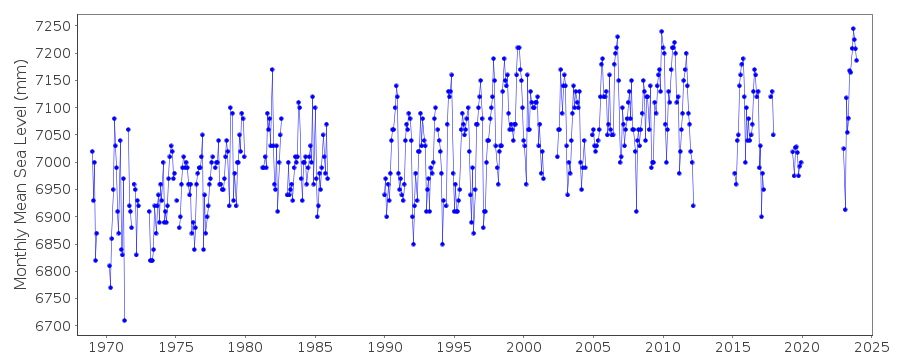
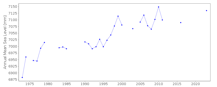
| Time span of RLR data: | 1969 – 2025 |
| RLR completeness (%): | 70 |
| Time span of metric data: | 1937 – 2025 |
| Metric completeness (%): | 49 |
| Date of last update: | 13 Mar 2026 |
| Green Arrow: | Current Station |
| Yellow Marker: | Neighbouring RLR Station |
| Red Marker: | Neighbouring Metric Station |
Please note: In many cases, the station position in our database is accurate to only one minute. Thus, the tide gauge may not appear to be on the coast.
Tide Gauge Data
Additional Data Sources (guide to additional data sources)
Nearby GNSS Stations from SONEL: KALMNearby Real Time Stations from VLIZ: kala
Station Documentation
Link to RLR information.Documentation added 1991-06-11
Kalamai 290/021 RLR(1978) is 9.5m below BM 220Documentation added 1997-03-11
The contributing authority advises that anomalous values are the result of met. influencesDocumentation added 2010-10-20
Following the revised way of recording the height of sea level at this station to recording upwards rather than downwards there is now an anomaly with the datum. Although the values of TGZ have been questioned several times the HNHS are adament they are correct.Because of this the station was flagged and reverted from RLR status to 'Metric' from June 2002 onwwards. However the station retains the RLR status so that the good RLR data is available on the database.Documentation added 2011-07-13
Following further information received from the Hellenic Navy Oceanographic Service the datum problem now seems to be resolved. The plotted data now appears correct. Therefore the station flag has been removed and all of the data reinstated as RLR.Documentation added 2013-08-07
Datum diagrams have been received from the Hellenic Navy. With these the RLR diagram has been redrawn. As a consequence the RLR factors have changed.Data Authority
Hellenic Navy Hydrographic ServiceGeographic Policy and International Relations Office
TGN 1040
Athens

![]()
![]()
![]()
