Data
- Obtaining
- Supplying
- High-Frequency
- Bottom Pressure Records
- Other Long Records
- GLOSS/ODINAFRICA Calibration Data
Donate
Donate to PSMSL
Data Notes
- Individual Station Data and Plot Notes
- Referencing the Data Set
- PSMSL Help File
- 2010 Changes to the PSMSL Data Files
Extracted from Database
13 Jul 2026
WARNING: QCFLAG EXISTS. PLEASE READ THE DOCUMENTATION.
Station Information
| Station ID: | 420 |
| Latitude: | 21.8 |
| Longitude: | 72.3 |
| Coastline code: | 500 |
| Station code: | 30 |
| Country: | INDIA |
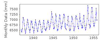
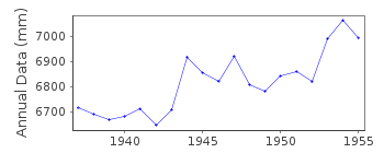
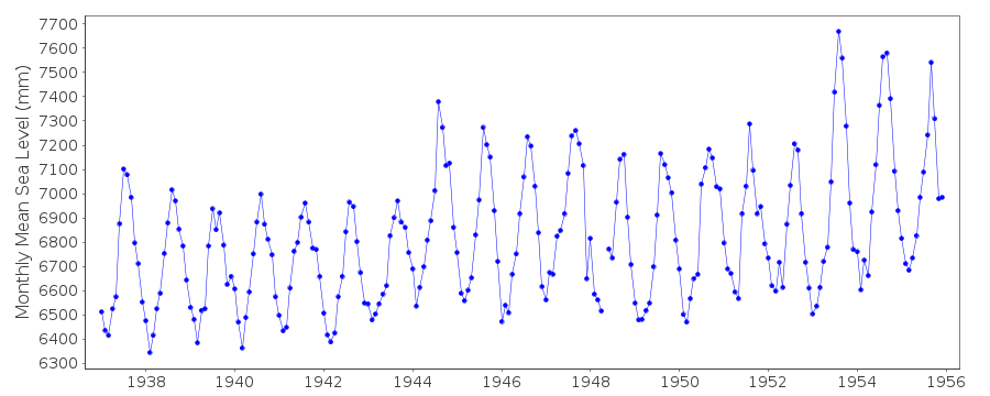
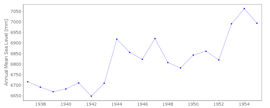
| Time span of data: | 1937 – 1955 |
| Completeness (%): | 100 |
| Date of last update: | 01 Jan 1980 |
| Green Arrow: | Current Station |
| Yellow Marker: | Neighbouring RLR Station |
| Red Marker: | Neighbouring Metric Station |
Please note: In many cases, the station position in our database is accurate to only one minute. Thus, the tide gauge may not appear to be on the coast.
Tide Gauge Data
Station Documentation
Link to RLR information.Documentation added 1991-06-11
Bhaunagar I 500/030 RLR(1955) is 13.0m below BM 21(PP)Documentation added 1993-03-17
Note larger seasonal cycle than for Bhaunagar II owing to different position with respect to river.Documentation added 1993-03-17
Possible datum shifts in RLR record at approximately 1944 and 1953.Documentation added 1994-08-04
For a discussion of interannual variability of sea level along the coasts of Pakistan and India, see Clarke and Liu, Journal of Physical Oceanography, 24, 1224, 1994.Documentation added 2002-12-06
SMRC Newsletter Jul-Dec 2001 reports high E coast correlation with SOI and MSL. MSL is much higher during La Nina tropical cyclones than during El Nino.ANNUAL MEANS FOR 1889-1893 - based on hourly heightsDocumentation added 2010-10-20
These comments are being added because of a review following the introduction of the new database. The station has been flagged because of the possible datum shifts within the data.However the station remains RLR. Bhaunagar I is now an historic station last data 1955Data Authority
Survey of IndiaGeodetic and Research Branch
17 E.C. Road
Dehra Dun
PIN 248 001

![]()
![]()
![]()
