Data
- Obtaining
- Supplying
- High-Frequency
- Bottom Pressure Records
- Other Long Records
- GLOSS/ODINAFRICA Calibration Data
Donate
Donate to PSMSL
Data Notes
- Individual Station Data and Plot Notes
- Referencing the Data Set
- PSMSL Help File
- 2010 Changes to the PSMSL Data Files
Extracted from Database
13 Jul 2026
Station Information
| Station ID: | 501 |
| Latitude: | -42.766667 |
| Longitude: | -65.033333 |
| GLOSS ID: | 191 |
| Coastline code: | 860 |
| Station code: | 31 |
| Country: | ARGENTINA |
| Time span of data: | 1944 – 2021 |
| Completeness (%): | 69 |
| Date of last update: | 01 Feb 2023 |
| Green Arrow: | Current Station |
| Yellow Marker: | Neighbouring RLR Station |
| Red Marker: | Neighbouring Metric Station |
Please note: In many cases, the station position in our database is accurate to only one minute. Thus, the tide gauge may not appear to be on the coast.
Tide Gauge Data
Additional Data Sources (guide to additional data sources)
Nearby Real Time Stations from VLIZ: madryFast Delivery Data from UHSLC station 731: hourly and daily
Research Quality Data from UHSLC station 731: hourly and daily
Station Documentation
Link to RLR information.Documentation - date unknown
Noticeable meteorological influencesDocumentation added 1991-06-11
Puerto Madryn 860/031 RLR(1977) is 12.2m below Punto Fijo No 2Documentation added 1993-05-06
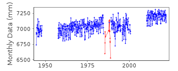
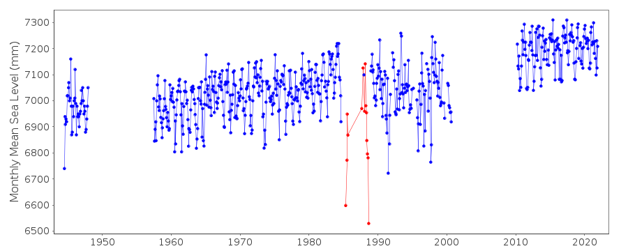
1985 and 1987: incomplete due to obstructions in the stilling wellDocumentation added 2010-10-25
During a review of the documentation the suspect flag on this station was removed and data points between May1985-Sept1988 were flagged as the data looks highly suspect.Documentation added 2023-02-01
The supplier sent an update for 2010-2021Data Authority
Servicio de Hidrografia NavalDepartmento Oceanografia
Av. Montes de Oca 2124
1271 Buenos Aires

![]()
![]()
![]()
