Data
- Obtaining
- Supplying
- High-Frequency
- Bottom Pressure Records
- Other Long Records
- GLOSS/ODINAFRICA Calibration Data
Donate
Donate to PSMSL
Data Notes
- Individual Station Data and Plot Notes
- Referencing the Data Set
- PSMSL Help File
- 2010 Changes to the PSMSL Data Files
Extracted from Database
20 Jul 2026
WARNING: QCFLAG EXISTS. PLEASE READ THE DOCUMENTATION.
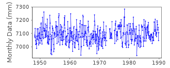
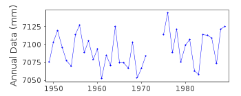
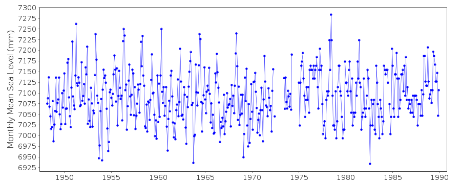
Station Information
| Station ID: | 549 |
| Latitude: | -33.833333 |
| Longitude: | 151.283333 |
| Coastline code: | 680 |
| Station code: | 151 |
| Country: | AUSTRALIA |
| Time span of data: | 1948 – 1989 |
| Completeness (%): | 95 |
| Date of last update: | 20 Feb 1990 |
| Green Arrow: | Current Station |
| Yellow Marker: | Neighbouring RLR Station |
| Red Marker: | Neighbouring Metric Station |
Please note: In many cases, the station position in our database is accurate to only one minute. Thus, the tide gauge may not appear to be on the coast.
Tide Gauge Data
Additional Data Sources (guide to additional data sources)
Fast Delivery Data from UHSLC station 333: hourly and dailyResearch Quality Data from UHSLC station 333: hourly and daily
Station Documentation
Link to RLR information.Documentation added 1991-06-11
Camp Cove 680/151 RLR(1969) is 8.6m below PM84Documentation added 1992-02-25
Records discontinued after 1989Documentation added 1995-05-02
Station density along some sections of the Australian coast has meant that station codes 601 onwards have been reordered compared to those in earlier versions of the PSMSL data set.1985 August - December, values for Fort Denison adopted 1989 July - December Fort Denison values adopted. Substituted data values are for station Sydney, Fort Denison ID 65.
Data Authority
Maritime Services Board of N.S.W.Box 32 G.P.O.
Sydney
N.S.W. 2001

![]()
![]()
![]()
