Data
- Obtaining
- Supplying
- High-Frequency
- Bottom Pressure Records
- Other Long Records
- GLOSS/ODINAFRICA Calibration Data
Donate
Donate to PSMSL
Data Notes
- Individual Station Data and Plot Notes
- Referencing the Data Set
- PSMSL Help File
- 2010 Changes to the PSMSL Data Files
Extracted from Database
13 Jul 2026
Station Information
| Station ID: | 563 |
| Latitude: | 21.108333 |
| Longitude: | -76.125 |
| GLOSS ID: | 276 |
| Coastline code: | 930 |
| Station code: | 31 |
| Country: | CUBA |
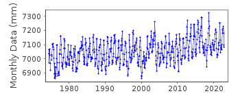
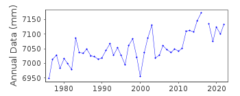
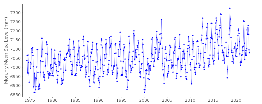
| Time span of RLR data: | 1974 – 2024 |
| RLR completeness (%): | 98 |
| Time span of metric data: | 1949 – 2024 |
| Metric completeness (%): | 80 |
| Date of last update: | 18 Jul 2025 |
| Green Arrow: | Current Station |
| Yellow Marker: | Neighbouring RLR Station |
| Red Marker: | Neighbouring Metric Station |
Please note: In many cases, the station position in our database is accurate to only one minute. Thus, the tide gauge may not appear to be on the coast.
Tide Gauge Data
Additional Data Sources (guide to additional data sources)
Research Quality Data from UHSLC station 244: hourly and dailyStation Documentation
Link to RLR information.Documentation - date unknown
Prior to 1970 data supplied by Negociado de Hidrografia, HavanaDocumentation added 2002-10-23
Gibara 930/031 RLR(1994) is 7.956m below TGBMDocumentation added 2010-08-26
Although an RLR factor existed Gibara was never actually an RLR station. Gibara has now been created an RLR station with RLR factor 5.032m.Both the benchmark and the TGZ are related to the Geodesic National Datum (GND). TGBM DATUM is 1.148m relative to GND while TGZ is -0.92m relative to GND. Data is referred to TGZ. Early data 1949-1972 has been left as 'Metric' as datum of the early data in unknown.Documentation added 2016-03-03
To reflect the fact that the monthly means supplied refer to TGZ and not GND the RLR diagram has been redrawn. As a result the RLRFAC has changed fron 5.032m to 6.032m. RLR (2008) is now 8.1m below TGBM DATUM.Documentation added 2016-06-29
Information received from Cuba the tide gauge sensors are listed as from 1970 a float recording hourly and from 2013 a datalogger coupled to the float with 6 minute frequency.Data Authority
Cuban National Tidal ServiceCalle 4 No. 304, E/3 Y 3-a
Playa
Cuidad Habana

![]()
![]()
![]()
