Data
- Obtaining
- Supplying
- High-Frequency
- Bottom Pressure Records
- Other Long Records
- GLOSS/ODINAFRICA Calibration Data
Donate
Donate to PSMSL
Data Notes
- Individual Station Data and Plot Notes
- Referencing the Data Set
- PSMSL Help File
- 2010 Changes to the PSMSL Data Files
Extracted from Database
13 Jul 2026
Station Information
| Station ID: | 58 |
| Latitude: | 60.398046 |
| Longitude: | 5.320487 |
| Coastline code: | 40 |
| Station code: | 221 |
| Country: | NORWAY |
| Time span of RLR data: | 1915 – 2025 |
| RLR completeness (%): | 93 |
| Time span of metric data: | 1883 – 2025 |
| Metric completeness (%): | 77 |
| Date of last update: | 30 Jan 2026 |
| Green Arrow: | Current Station |
| Yellow Marker: | Neighbouring RLR Station |
| Red Marker: | Neighbouring Metric Station |
Please note: In many cases, the station position in our database is accurate to only one minute. Thus, the tide gauge may not appear to be on the coast.
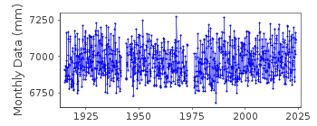
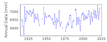
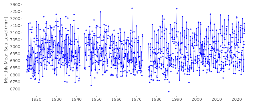
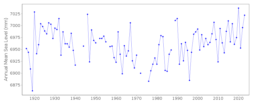
Tide Gauge Data
Additional Data Sources (guide to additional data sources)
Nearby GNSS Stations from SONEL: BERHNearby Real Time Stations from VLIZ: berg
Station Documentation
Link to RLR information.Documentation added 1991-06-11
Bergen 040/221 RLR(1964) is 9.7m below BM B33 N90Documentation added 1992-12-14
UP TO 1986 ACODE=03Documentation added 1995-03-30
tide gauge network modernised, new equipment installed in 1988Documentation added 2010-07-19
The dataset for Bergen has been revised. According to the Norwegian website the dataset begins 01/01/1915. However PSMSL hold data for 1883-1889 this does not appear on the Norwegian website.Primary bench mark is B33 N202 at 2.963m above TGZ. RLR was recalculated using 2008 as the RLR year. The revised RLR factor is 6.937m. RLR (2008) is 9.9m below TGBM B33 N202.Documentation added 2012-09-05
For information on see level rise along the Norwegian coast see paper "Contributions to sea level variability along the Norwegian coast for 1960-2010" by K Richter, J.E.O. Nilsen and H Drange.Data Authority
Norwegian Mapping AuthorityHydrographic Service
Po. Box 60
4001 Stavanger

![]()
![]()
![]()
