Data
- Obtaining
- Supplying
- High-Frequency
- Bottom Pressure Records
- Other Long Records
- GLOSS/ODINAFRICA Calibration Data
Donate
Donate to PSMSL
Data Notes
- Individual Station Data and Plot Notes
- Referencing the Data Set
- PSMSL Help File
- 2010 Changes to the PSMSL Data Files
Extracted from Database
13 Jul 2026
Station Information
| Station ID: | 598 |
| Latitude: | 16.738333 |
| Longitude: | -169.53 |
| GLOSS ID: | 109 |
| Coastline code: | 760 |
| Station code: | 11 |
| Country: | UNITED STATES MINOR OUTLYING ISLANDS |
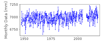
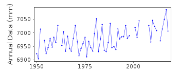
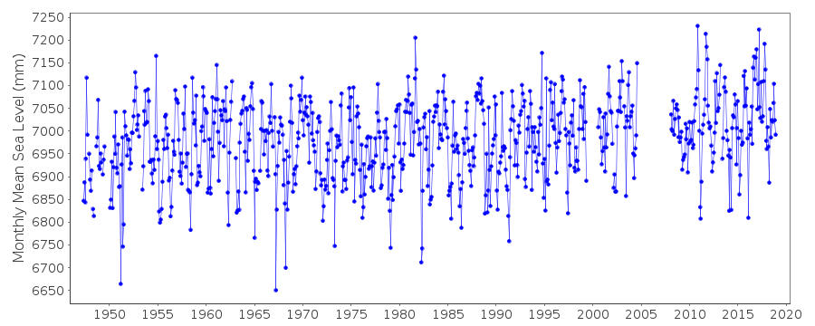
| Time span of data: | 1947 – 2018 |
| Completeness (%): | 90 |
| Date of last update: | 28 Jan 2020 |
| Green Arrow: | Current Station |
| Yellow Marker: | Neighbouring RLR Station |
| Red Marker: | Neighbouring Metric Station |
Please note: In many cases, the station position in our database is accurate to only one minute. Thus, the tide gauge may not appear to be on the coast.
Tide Gauge Data
Additional Data Sources (guide to additional data sources)
Nearby Real Time Stations from VLIZ: johnFast Delivery Data from UHSLC station 52: hourly and daily
Research Quality Data from UHSLC station 52: hourly and daily
Station Documentation
Link to RLR information.Documentation added 1991-06-11
Johnston Island 760/011 RLR(1975) is 9.9m below BMNo21 1964Documentation added 2011-11-24
Using information from the NOAA website the RLR diagram has been revised. Primary benchmark is now NO 13 1955 2.85m above gauge datum this appeared as a secondary benchmark on the original diagram. Previous Primary benchmark NO 21 1964 remains in the NOAA reports.Data Authority
University of Hawaii Sea Level CenterDepartment of Oceanography Division of Natural Sciences
1000 Pope Road
Honolulu
Hawaii 96822

![]()
![]()
![]()
