Data
- Obtaining
- Supplying
- High-Frequency
- Bottom Pressure Records
- Other Long Records
- GLOSS/ODINAFRICA Calibration Data
Donate
Donate to PSMSL
Data Notes
- Individual Station Data and Plot Notes
- Referencing the Data Set
- PSMSL Help File
- 2010 Changes to the PSMSL Data Files
Extracted from Database
20 Jul 2026
Station Information
| Station ID: | 637 |
| Latitude: | -19.25 |
| Longitude: | 146.833333 |
| GLOSS ID: | 60 |
| Coastline code: | 680 |
| Station code: | 51 |
| Country: | AUSTRALIA |
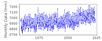
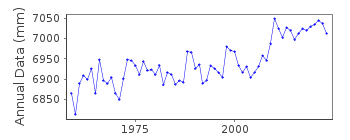
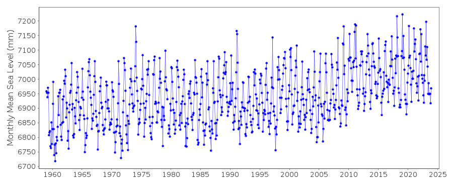
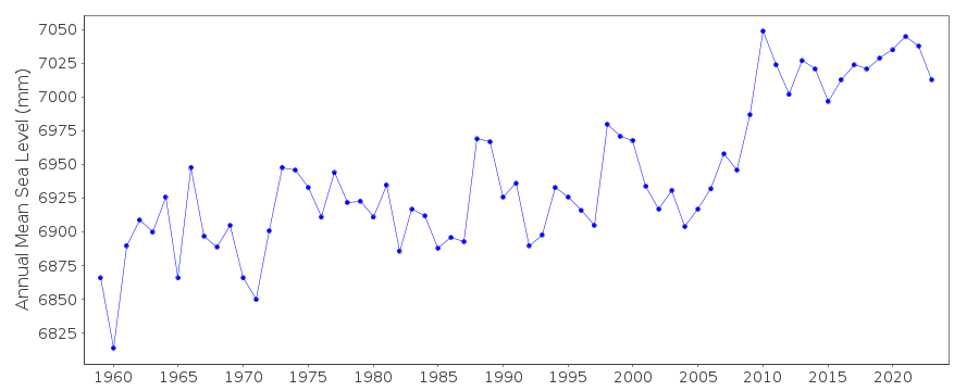
| Time span of RLR data: | 1959 – 2025 |
| RLR completeness (%): | 98 |
| Time span of metric data: | 1951 – 2025 |
| Metric completeness (%): | 91 |
| Date of last update: | 20 Mar 2025 |
| Green Arrow: | Current Station |
| Yellow Marker: | Neighbouring RLR Station |
| Red Marker: | Neighbouring Metric Station |
Please note: In many cases, the station position in our database is accurate to only one minute. Thus, the tide gauge may not appear to be on the coast.
Tide Gauge Data
Additional Data Sources (guide to additional data sources)
Fast Delivery Data from UHSLC station 334: hourly and dailyResearch Quality Data from UHSLC station 334: hourly and daily
Station Documentation
Link to RLR information.Documentation added 1995-05-02
Station density along some sections of the Australian coast has meant that station codes 601 onwards have been re-ordered compared to those in earlier versions of the PSMSL data set.Documentation added 1996-05-17
Data up to 1959 supplied by Austarlian Ocean Data Centre N.S.W. Revised data for 1959-1985 supplied by the National Tidal Centre, Bureau of Meteorology, South AustraliaDocumentation added 1998-01-22
Gauge type currently float/stilling well Queensland Beach Protection Authority operates analogue and digital recorders on nearby Ro-Ro Wharf.Documentation added 2002-05-31
Townsville I 680/051 RLR(2000) is 11.379 below BM NMV/B/309A From metadata downloaded from NTC the primary benchmark is now PSM 100011 9.025m above the datum. Tide gauge is a MACE recorder model 2000.Data Authority
National Tidal CentreBureau of Meteorology
PO Box 421
Kent Town 5071
South Australia
Documentation added 2010-08-12
Formerly known as the National Tidal Facility

![]()
![]()
![]()
