Data
- Obtaining
- Supplying
- High-Frequency
- Bottom Pressure Records
- Other Long Records
- GLOSS/ODINAFRICA Calibration Data
Donate
Donate to PSMSL
Data Notes
- Individual Station Data and Plot Notes
- Referencing the Data Set
- PSMSL Help File
- 2010 Changes to the PSMSL Data Files
Extracted from Database
20 Jul 2026
Station Information
| Station ID: | 639 |
| Latitude: | 1.833333 |
| Longitude: | -78.733333 |
| GLOSS ID: | 171 |
| Coastline code: | 842 |
| Station code: | 21 |
| Country: | COLOMBIA |
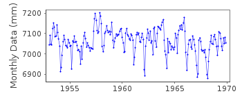
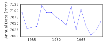
| Time span of RLR data: | 1953 – 1969 |
| RLR completeness (%): | 100 |
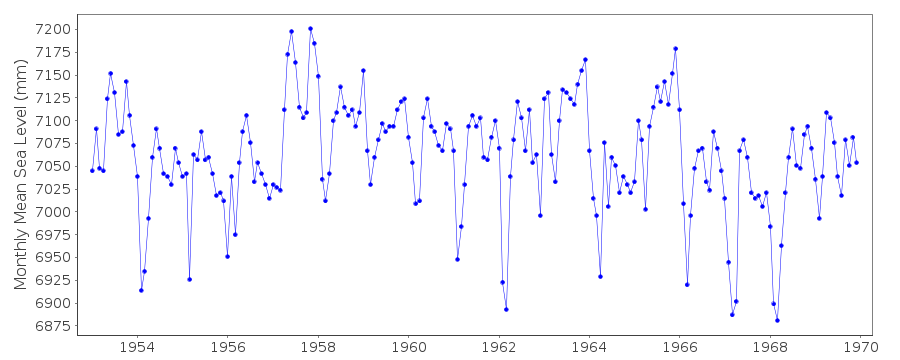
| Time span of metric data: | 1951 – 2014 |
| Metric completeness (%): | 84 |
| Date of last update: | 04 Nov 2015 |
| Green Arrow: | Current Station |
| Yellow Marker: | Neighbouring RLR Station |
| Red Marker: | Neighbouring Metric Station |
Please note: In many cases, the station position in our database is accurate to only one minute. Thus, the tide gauge may not appear to be on the coast.
Tide Gauge Data
Additional Data Sources (guide to additional data sources)
Nearby GNSS Stations from SONEL: TUMANearby Real Time Stations from VLIZ: tumc2
Research Quality Data from UHSLC station 303: hourly and daily
Station Documentation
Link to RLR information.Documentation added 1992-11-30
December 1989 an earthquake caused a vertical land submergence or apparent sea level rise of approximately 15.2cm1953-90 Data revised,November 1992
Documentation added 1993-04-19
The Colombian earthquake of 12 December 1979 caused the coast around Tumaco (station code 842/021) to subside up to 1.6m - see Herd et al. 1979, Science, 211, 441-445.Documentation added 1993-04-23
1988-92 data from several tide gauges as follows:Jan 88-Sept 89 Stevens,Dec 89-Nov 90 ADR Digital,Dec 90-Oct 91 Fuess,Nov 91-June 92 ADR Digital,July Nov 92 Seba,Dec 92 onwards DigitalDocumentation added 1993-05-06
Datum shift queries in 1973,1974 and 1984Documentation added 1993-05-06
Datum shift in 1990Documentation added 1993-07-12
Tumaco 842/021 RLR(1964) is 10.3m below BM1Documentation added 2004-10-05
Data from 1997 on received from University of Hawaii Sea Level CenterDocumentation added 2012-01-18
Using data from the latest UHSLC JASL cd the 'METRIC' dataset has been updated. Data values for 2001-2011 have been added to the dataset. The whole dataset has several datum shifts in it.Documentation added 2015-11-04
Updated JASL data for 2011-2014 added to the 'Metric' plot.Data Authority
I.D.E.A.M.Carrera 5a, No.15-80 Piso 18
Aa 18633 Santafe de Bogota Dc

![]()
![]()
![]()
