Data
- Obtaining
- Supplying
- High-Frequency
- Bottom Pressure Records
- Other Long Records
- GLOSS/ODINAFRICA Calibration Data
Donate
Donate to PSMSL
Data Notes
- Individual Station Data and Plot Notes
- Referencing the Data Set
- PSMSL Help File
- 2010 Changes to the PSMSL Data Files
Extracted from Database
13 Jul 2026
Station Information
| Station ID: | 690 |
| Latitude: | 21.3 |
| Longitude: | -89.666667 |
| GLOSS ID: | 213 |
| Coastline code: | 920 |
| Station code: | 1 |
| Country: | MEXICO |
| Time span of data: | 1952 – 2013 |
| Completeness (%): | 54 |
| Date of last update: | 24 Jun 2015 |
| Green Arrow: | Current Station |
| Yellow Marker: | Neighbouring RLR Station |
| Red Marker: | Neighbouring Metric Station |
Please note: In many cases, the station position in our database is accurate to only one minute. Thus, the tide gauge may not appear to be on the coast.
Tide Gauge Data
Additional Data Sources (guide to additional data sources)
Nearby GNSS Stations from SONEL: PROXNearby Real Time Stations from VLIZ: prog2, prog
Research Quality Data from UHSLC station 721: hourly and daily
Station Documentation
Link to RLR information.Documentation added 1991-06-11
Progreso 920/001 RLR(1964) is 13.8m below BM1Documentation added 1993-07-29
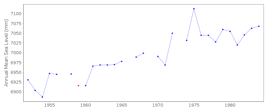
Anomalously low value May 1959 - correct as received from authority.Documentation added 2012-01-12
Regarding the comment above re. the data spike in May 1959. In the old system it was only possible to flag a whole year as suspect. This is not the case with the new database. As the rest of the data for 1959 looks correct the flags have been removed so May 1959 is the only month flagged.Documentation added 2015-06-24
Levelling information has been received from UNAM. Primary benchmark remains BM 1. However the TGZ is now 12.301m below BM 1.Data Authority
Servicio Mareografico NacionalInstituto de Geofisica, Ciudad Universitaria
Delegacion de Coyoacan
04510 Mexico D.F.

![]()
![]()
![]()
