Data
- Obtaining
- Supplying
- High-Frequency
- Bottom Pressure Records
- Other Long Records
- GLOSS/ODINAFRICA Calibration Data
Donate
Donate to PSMSL
Data Notes
- Individual Station Data and Plot Notes
- Referencing the Data Set
- PSMSL Help File
- 2010 Changes to the PSMSL Data Files
Extracted from Database
13 Jul 2026
WARNING: QCFLAG EXISTS. PLEASE READ THE DOCUMENTATION.
Station Information
| Station ID: | 726 |
| Latitude: | -25.016667 |
| Longitude: | -47.933333 |
| GLOSS ID: | 194 |
| Coastline code: | 874 |
| Station code: | 51 |
| Country: | BRAZIL |
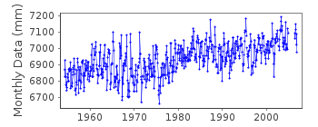
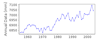
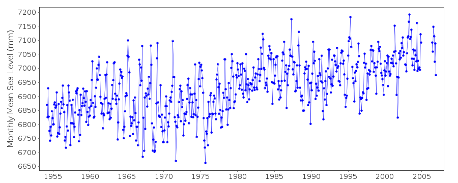
| Time span of data: | 1954 – 2006 |
| Completeness (%): | 97 |
| Date of last update: | 18 Jul 2007 |
| Green Arrow: | Current Station |
| Yellow Marker: | Neighbouring RLR Station |
| Red Marker: | Neighbouring Metric Station |
Please note: In many cases, the station position in our database is accurate to only one minute. Thus, the tide gauge may not appear to be on the coast.
Tide Gauge Data
Additional Data Sources (guide to additional data sources)
Nearby GNSS Stations from SONEL: NEIAFast Delivery Data from UHSLC station 281: hourly and daily
Research Quality Data from UHSLC station 281: hourly and daily
Station Documentation
Link to RLR information.Documentation added 1993-07-12
Cananeia 874/051 RLR(1984) is 9.4m below BM RN S/No Cota=2.465Documentation added 1996-12-10
Although this station evidently has a large apparent rate of rise of sea level, it has operated in the same location throughout,and annual site levellings show no differential movements in the immediate vicinity of the gauge. The large rate maybe connected to the geology of the nearby mountain to the SW, while the large interannual variability may be a result of the estuary location. (Information from Prof.A.de Mesquita, Univ. of Sao Paulo).Documentation added 2002-11-11
Cananeia datums are suspect due to Tide Staff slippage, probably in 1989. RLR is given as a constant correction but there is a datum difference of approx. 5cms after 1989.Documentation added 2007-04-20
Following receipt of a revised listing from Brazil - full dataset was updated 23.01.07Data Authority
Instituto OceanograficoUniversidade de Sao Paulo
Cidade Universitaria, Butanta, Cep 05508
Sao Paulo

![]()
![]()
![]()
