Data
- Obtaining
- Supplying
- High-Frequency
- Bottom Pressure Records
- Other Long Records
- GLOSS/ODINAFRICA Calibration Data
Donate
Donate to PSMSL
Data Notes
- Individual Station Data and Plot Notes
- Referencing the Data Set
- PSMSL Help File
- 2010 Changes to the PSMSL Data Files
Extracted from Database
20 Jul 2026
Station Information
| Station ID: | 761 |
| Latitude: | 45.0833 |
| Longitude: | 13.6283 |
| Coastline code: | 280 |
| Station code: | 6 |
| Country: | CROATIA |
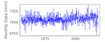
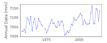
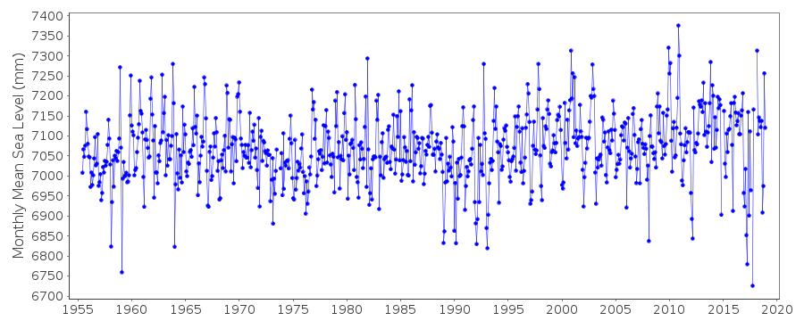
| Time span of data: | 1955 – 2018 |
| Completeness (%): | 98 |
| Date of last update: | 11 Jul 2019 |
| Green Arrow: | Current Station |
| Yellow Marker: | Neighbouring RLR Station |
| Red Marker: | Neighbouring Metric Station |
Please note: In many cases, the station position in our database is accurate to only one minute. Thus, the tide gauge may not appear to be on the coast.
Tide Gauge Data
Station Documentation
Link to RLR information.Documentation added 1992-03-04
Prior to 1990 data from Hidrografski Institut, SplitDocumentation added 1994-07-14
Values for February - March 1958 and November - December 1960 seem low compared to Trieste. Values correct as received from authority.Documentation added 1996-01-12
Tide gauge of the State Hydrographic Institute at SplitDocumentation added 1996-01-12
Gauge=A. Ott, KemptenDocumentation added 2000-01-25
Rovinj 280/006 RLR(1964) is 11.9m below BM = Contact PointDocumentation added 2011-01-20
From station report tide gauge at Rovinj operational from 1955 onwards. Primary benchmark BP 82 is 5.820m above TGZ. Benchmark AP 807 is 4.106m above TGZ. RLR factor is 6.080m.Documentation added 2019-03-14
Referring to the comment of 1994-07-14 dataplots for both Trieste id. 154 and Rovinj have been plotted. The comparison is generally good. Because of this the previous data flags have been removed.Data Authority
Hidrografski Institut of Rep. of CroatiaZrinsko-Frankopanska 161
21000 Split

![]()
![]()
![]()
