Data
- Obtaining
- Supplying
- High-Frequency
- Bottom Pressure Records
- Other Long Records
- GLOSS/ODINAFRICA Calibration Data
Donate
Donate to PSMSL
Data Notes
- Individual Station Data and Plot Notes
- Referencing the Data Set
- PSMSL Help File
- 2010 Changes to the PSMSL Data Files
Extracted from Database
20 Jul 2026
Station Information
| Station ID: | 8 |
| Latitude: | 53.898889 |
| Longitude: | 11.458056 |
| Coastline code: | 120 |
| Station code: | 22 |
| Country: | GERMANY |
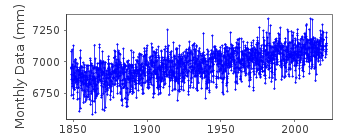
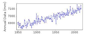
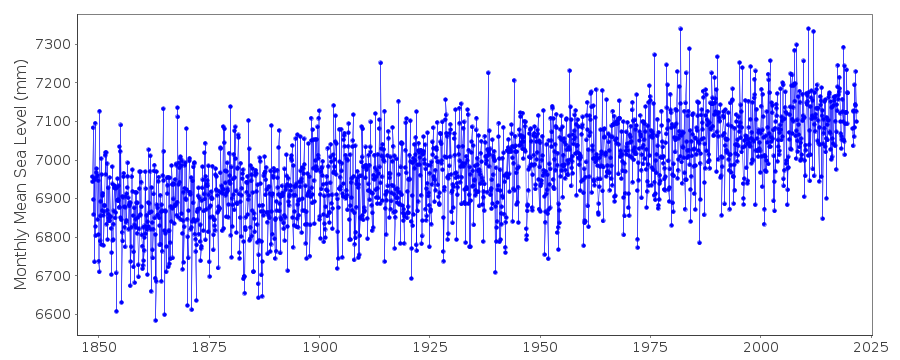
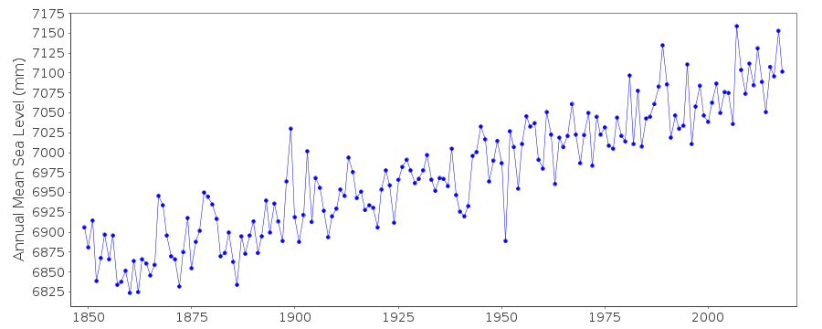
| Time span of data: | 1848 – 2025 |
| Completeness (%): | 99 |
| Date of last update: | 07 Nov 2025 |
| Green Arrow: | Current Station |
| Yellow Marker: | Neighbouring RLR Station |
| Red Marker: | Neighbouring Metric Station |
Please note: In many cases, the station position in our database is accurate to only one minute. Thus, the tide gauge may not appear to be on the coast.
Tide Gauge Data
Station Documentation
Link to RLR information.Documentation added 1992-07-09
Gauges in eastern Germany (Wismar, Warnemunde, Sassnitz, Koserow) as of March 1992 are type 'Steremat', vertical drum, swimmer principle measures 1:10, continuos registration on paper chart information from L. Ballani, Potsdam.Documentation added 1994-08-02
These values are of Wismar MSL relative to the HN datum as computed by the University of Dresden. See the report "Die Reduktion historischer Wasserstandsmessungen an der Kueste Mecklenburg-Vorpommerns auf das Hoehensystem HN76" by G.Liebsch, R.Dietrich, L.Ballani and G.Langer.Documentation added 1994-09-29
Prior to 1894 readings from tide pole. 1894 analogue gauge installed. 1945-52 tide pole while new gauge installed. Dresden analyses based on:1848-1882 1 reading per day, corrected for tidal effects
1883-1894(June) 4 readings per day, corrected for tidal effects
1894(July)-1945 4 readings per day from charts
1946-1952 1 to 4 readings per day, corrected for tidal effects
1953-1980 4 readings per day
So, tidal aliasing effects should be largely removed from Desden values
Documentation added 2002-01-23
Wismar data up to 1992 supplied by Technische Universitat Dresden (auth=H3). Data 1993- supplied by Bundesamt fur Seeschiffahrt und Hydrographie (BSH), Hamburg (auth=16).Documentation added 2010-08-09
The data for Wismar was measured to Normal Null which is a German datum related to Potsdam near Berlin. It is similar to ODN in the UK or NAP in Holland. It is unusual therefore to relate the data to RLR as it 'breaks the rules' of RLR. Data now refers to TGZ.Data Authority
Bundesamt fur Seeschifffahrt und Hydrographie HamburgBernhard-Nocht-Strasse 78
20359 Hamburg
Documentation added 1993-10-05
FORMERLY THE DEUTSCHES HYDROGRAPHISCHES INSTITUT

![]()
![]()
![]()
