Data
- Obtaining
- Supplying
- High-Frequency
- Bottom Pressure Records
- Other Long Records
- GLOSS/ODINAFRICA Calibration Data
Donate
Donate to PSMSL
Data Notes
- Individual Station Data and Plot Notes
- Referencing the Data Set
- PSMSL Help File
- 2010 Changes to the PSMSL Data Files
Extracted from Database
22 Jun 2026
Station Information
| Station ID: | 825 |
| Latitude: | -23.853833 |
| Longitude: | 151.313667 |
| Coastline code: | 680 |
| Station code: | 71 |
| Country: | AUSTRALIA |
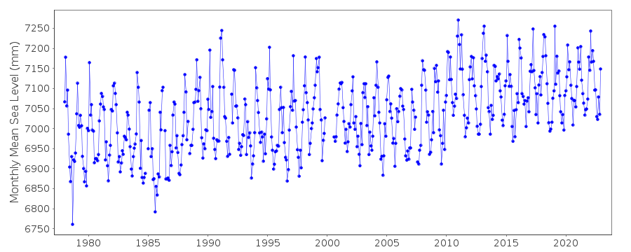
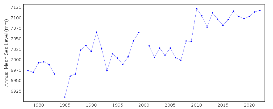
| Time span of RLR data: | 1978 – 2024 |
| RLR completeness (%): | 98 |
| Time span of metric data: | 1957 – 2024 |
| Metric completeness (%): | 71 |
| MTL Data: | 1957-1960 |
| MTL-MSL (mm): | Not Applied |
| Date of last update: | 01 Jun 2026 |
| Green Arrow: | Current Station |
| Yellow Marker: | Neighbouring RLR Station |
| Red Marker: | Neighbouring Metric Station |
Please note: In many cases, the station position in our database is accurate to only one minute. Thus, the tide gauge may not appear to be on the coast.
Tide Gauge Data
Station Documentation
Link to RLR information.Documentation - date unknown
Data up to 1978 supplied by C.S.I.R.O. Tasmania as High and Low watersDocumentation added 1995-05-02
Station density along some sections of the Australian coast has meant that station codes 601 onwards have been re-ordered compared to those in earlier versions of the PSMSL data set.Documentation added 1996-05-17
Data for 1978-1985 revised with new set received from the National Tidal Centre, Bureau of Meteorology, South AustraliaDocumentation added 2010-09-16
Tide gauge zero confirmed as LAT, with benchmark RM2 6.21 m above it. RLR (2009) is defined as 10.9 m below RM2.Documentation added 2016-01-22
The value of MTL-MSL is unknown, though estimates are -20 mm for Rosslyn Bay and 4 mm for Bundaberg. Given that the level is probably unknown to more than 10 mm, we have set the 001 flag for the MTL for the period 1957-1977.Documentation added 2016-07-12
Using updated metadata from the NTC website the RLR diagram for Gladstone has been revised. Primary benchmark is now PM 10855 5.66m above LAT.Data Authority
National Tidal CentreBureau of Meteorology
PO Box 421
Kent Town 5071
South Australia
Documentation added 2010-08-12
Formerly known as the National Tidal Facility

![]()
![]()
![]()
