Data
- Obtaining
- Supplying
- High-Frequency
- Bottom Pressure Records
- Other Long Records
- GLOSS/ODINAFRICA Calibration Data
Donate
Donate to PSMSL
Data Notes
- Individual Station Data and Plot Notes
- Referencing the Data Set
- PSMSL Help File
- 2010 Changes to the PSMSL Data Files
Extracted from Database
20 Jul 2026
Station Information
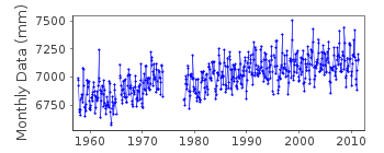
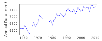
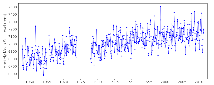
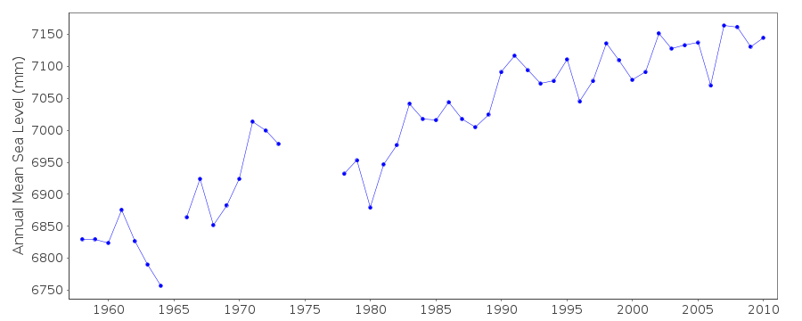
| Station ID: | 828 |
| Latitude: | 29.285 |
| Longitude: | -94.788333 |
| GLOSS ID: | 217 |
| Coastline code: | 940 |
| Station code: | 7 |
| Country: | UNITED STATES |
| Time span of data: | 1957 – 2011 |
| Completeness (%): | 89 |
| Link to ellipsoid: | Available |
| Date of last update: | 07 Mar 2012 |
| Green Arrow: | Current Station |
| Yellow Marker: | Neighbouring RLR Station |
| Red Marker: | Neighbouring Metric Station |
Please note: In many cases, the station position in our database is accurate to only one minute. Thus, the tide gauge may not appear to be on the coast.
Tide Gauge Data
Additional Data Sources (guide to additional data sources)
Nearby GNSS Stations from SONEL: TXGA, TXGV, N301, GAL1Nearby Real Time Stations from VLIZ: gptx
Fast Delivery Data from UHSLC station 775: hourly and daily
Fast Delivery Data from UHSLC station 767: hourly and daily
Research Quality Data from UHSLC station 775: hourly and daily
Research Quality Data from UHSLC station 767: hourly and daily
Station Documentation
Link to RLR information.Documentation added 1991-06-11
Galveston 940/007 RLR(1971) is 14.3m below BM43Documentation added 1993-07-29
Many stations on the Gulf coast have large values for September 1961.Documentation added 1994-07-14
For a discussion of submergence near to Galveston, Freeport and Sabine Pass, see Emery and Aubrey (Sea Levels, Land Levels and Tide Gauges), 1991, Springer-Verlag, page 39.Data Authority
N.O.A.A. / N.O.S.N/oes33, Ssmc4, Room 6531
1305 East-West Highway
Silver Spring,
MD 20910

![]()
![]()
![]()
