Data
- Obtaining
- Supplying
- High-Frequency
- Bottom Pressure Records
- Other Long Records
- GLOSS/ODINAFRICA Calibration Data
Donate
Donate to PSMSL
Data Notes
- Individual Station Data and Plot Notes
- Referencing the Data Set
- PSMSL Help File
- 2010 Changes to the PSMSL Data Files
Extracted from Database
20 Jul 2026
Station Information
| Station ID: | 833 |
| Latitude: | -37.07366 |
| Longitude: | 149.907739 |
| Coastline code: | 680 |
| Station code: | 171 |
| Country: | AUSTRALIA |
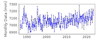
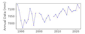
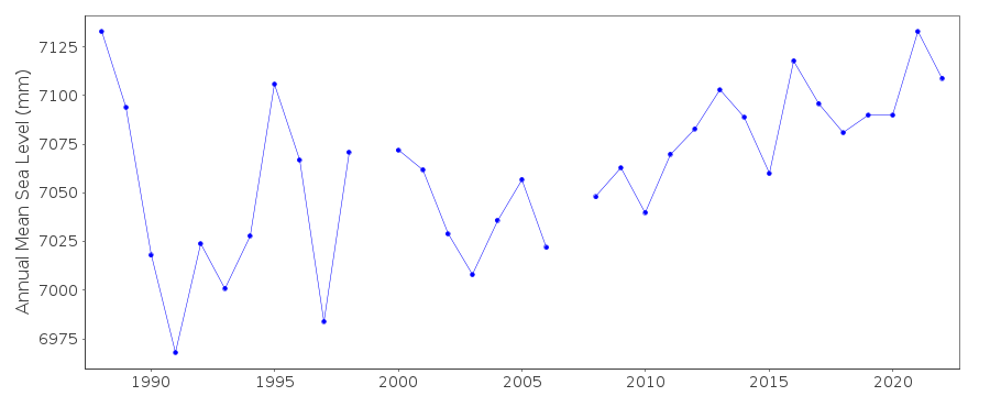
| Time span of RLR data: | 1986 – 2025 |
| RLR completeness (%): | 95 |
| Time span of metric data: | 1957 – 2025 |
| Metric completeness (%): | 64 |
| Date of last update: | 29 Jan 2026 |
| Green Arrow: | Current Station |
| Yellow Marker: | Neighbouring RLR Station |
| Red Marker: | Neighbouring Metric Station |
Please note: In many cases, the station position in our database is accurate to only one minute. Thus, the tide gauge may not appear to be on the coast.
Tide Gauge Data
Additional Data Sources (guide to additional data sources)
Nearby GNSS Stations from SONEL: EDENNearby Real Time Stations from VLIZ: tbwc
Station Documentation
Link to RLR information.Documentation added 1995-05-02
station density along some sections of the Australian coast has meant that station codes 601 onwards have been reordered compared to those in earlier versions of the PSMSL data set.Documentation added 1996-05-20
May 1996: data for 1957-84 revised in new set received from National Tidal Centre, Bureau of MeteorologyDocumentation added 2013-08-05
Eden data for July 1989 onwards has now been made RLR. RLR factor is 6.213m. Early data not good enough for RLR.Documentation added 2016-10-04
Using information supplied a new Primary benchmark has been added to the RLR diagram. Benchmark is PM28485 10.37m above datum Twofold Bay Hydro Datum.Data Authority
Manly Hydraulics Laboratory110B King Street
Manly Vale
NSW 2093

![]()
![]()
![]()
