Data
- Obtaining
- Supplying
- High-Frequency
- Bottom Pressure Records
- Other Long Records
- GLOSS/ODINAFRICA Calibration Data
Donate
Donate to PSMSL
Data Notes
- Individual Station Data and Plot Notes
- Referencing the Data Set
- PSMSL Help File
- 2010 Changes to the PSMSL Data Files
Extracted from Database
20 Jul 2026
Station Information
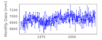
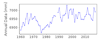
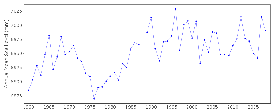
| Station ID: | 913 |
| Latitude: | -65.246233 |
| Longitude: | -64.257417 |
| GLOSS ID: | 188 |
| Coastline code: | 999 |
| Station code: | 3 |
| Country: | ANTARCTICA |
| Time span of data: | 1958 – 2018 |
| Completeness (%): | 98 |
| Date of last update: | 04 Jun 2019 |
| Green Arrow: | Current Station |
| Yellow Marker: | Neighbouring RLR Station |
| Red Marker: | Neighbouring Metric Station |
Please note: In many cases, the station position in our database is accurate to only one minute. Thus, the tide gauge may not appear to be on the coast.
Tide Gauge Data
Additional Data Sources (guide to additional data sources)
Nearby GNSS Stations from SONEL: VNADNearby Real Time Stations from VLIZ: vern
Fast Delivery Data from UHSLC station 700: hourly and daily
Research Quality Data from UHSLC station 700: hourly and daily
Station Documentation
Link to RLR information.Documentation added 1997-11-10
Data before March 1984 was received from the British Antarctic SurveyDocumentation added 1998-06-01
Processing of Faraday data 1958-95 is described in a PSMSL internal note by P.L.Woodworth dated 17 December 1996.Documentation added 1998-06-01
Argentine Islands id.913 RLR(1987) is 7.9m below BM CDocumentation added 1999-06-30
Argentine Islands station is also known as Faraday (British Antarctic Survey base) and now Vernadsky (Ukraine Antarctic base)Data Authority
British Oceanographic Data CentreNational Oceanography Centre
Joseph Proudman Building, 6 Brownlow Street
Liverpool
L3 5DA

![]()
![]()
![]()
