Data
- Obtaining
- Supplying
- High-Frequency
- Bottom Pressure Records
- Other Long Records
- GLOSS/ODINAFRICA Calibration Data
Donate
Donate to PSMSL
Data Notes
- Individual Station Data and Plot Notes
- Referencing the Data Set
- PSMSL Help File
- 2010 Changes to the PSMSL Data Files
Extracted from Database
13 Jul 2026
Station Information
| Station ID: | 927 |
| Latitude: | -0.9 |
| Longitude: | -89.616667 |
| Coastline code: | 845 |
| Station code: | 21 |
| Country: | ECUADOR |
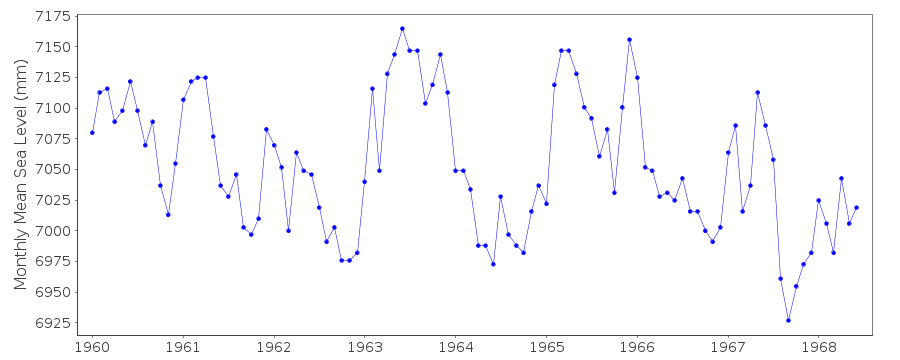
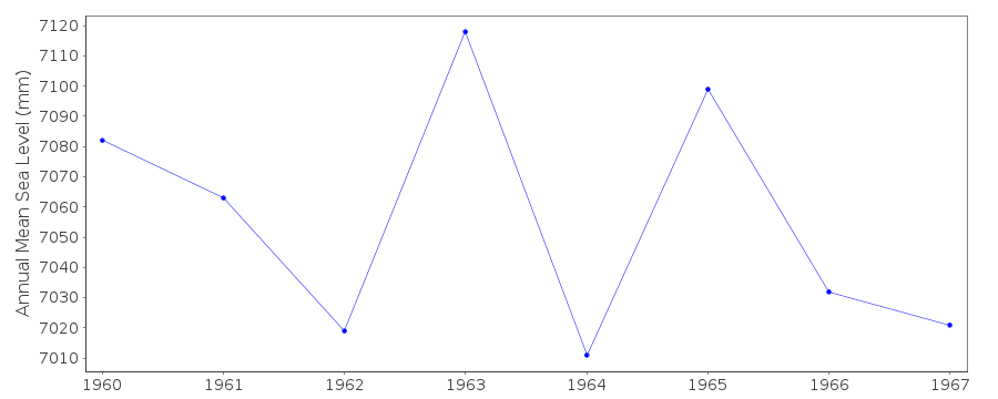
| Time span of RLR data: | 1960 – 1968 |
| RLR completeness (%): | 94 |
| Time span of metric data: | 1958 – 1968 |
| Metric completeness (%): | 83 |
| Date of last update: | 01 Jan 1980 |
| Green Arrow: | Current Station |
| Yellow Marker: | Neighbouring RLR Station |
| Red Marker: | Neighbouring Metric Station |
Please note: In many cases, the station position in our database is accurate to only one minute. Thus, the tide gauge may not appear to be on the coast.
Tide Gauge Data
Station Documentation
Link to RLR information.Documentation added 1991-06-11
San Cristobal 845/021 RLR(1964) is 10.6m below BM BW-1Documentation added 2012-01-26
This is an historic station last data 1968. No further information appears on the NOAA website. Station has been labelled 'inactive'.Data Authority
N.O.A.A. / N.O.S.N/oes33, Ssmc4, Room 6531
1305 East-West Highway
Silver Spring,
MD 20910

![]()
![]()
![]()
