Data
- Obtaining
- Supplying
- High-Frequency
- Bottom Pressure Records
- Other Long Records
- GLOSS/ODINAFRICA Calibration Data
Donate
Donate to PSMSL
Data Notes
- Individual Station Data and Plot Notes
- Referencing the Data Set
- PSMSL Help File
- 2010 Changes to the PSMSL Data Files
Extracted from Database
13 Jul 2026
Station Information
| Station ID: | 933 |
| Latitude: | 21.583333 |
| Longitude: | 111.816667 |
| GLOSS ID: | 78 |
| Coastline code: | 610 |
| Station code: | 2 |
| Country: | CHINA |
| Time span of data: | 1959 – 2024 |
| Completeness (%): | 99 |
| Date of last update: | 27 Mar 2025 |
| Green Arrow: | Current Station |
| Yellow Marker: | Neighbouring RLR Station |
| Red Marker: | Neighbouring Metric Station |
Please note: In many cases, the station position in our database is accurate to only one minute. Thus, the tide gauge may not appear to be on the coast.
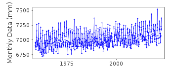
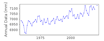
Tide Gauge Data
Additional Data Sources (guide to additional data sources)
Nearby Real Time Stations from VLIZ: zhapResearch Quality Data from UHSLC station 635: hourly and daily
Station Documentation
Link to RLR information.Documentation added 1994-05-23
1959-74 DATA RECEIVED FROM TOGA OFFICEDocumentation added 1998-04-22
Following the receipt of TGBM information the RLR datum was redefined.Up to October 1967 recordings were made with gauging rods.
In November 1967 a float gauge type HJC 1 was installed.
Data Authority
National Marine Data and Information Service (NMDIS)No. 93 Liuwei Road
Tianjin 300171

![]()
![]()
![]()
