Data
- Obtaining
- Supplying
- High-Frequency
- Bottom Pressure Records
- Other Long Records
- GLOSS/ODINAFRICA Calibration Data
Donate
Donate to PSMSL
Data Notes
- Individual Station Data and Plot Notes
- Referencing the Data Set
- PSMSL Help File
- 2010 Changes to the PSMSL Data Files
Extracted from Database
20 Jul 2026
Station Information
| Station ID: | 935 |
| Latitude: | -12.471778 |
| Longitude: | 130.845861 |
| GLOSS ID: | 62 |
| Coastline code: | 680 |
| Station code: | 11 |
| Country: | AUSTRALIA |
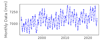
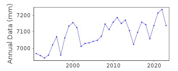
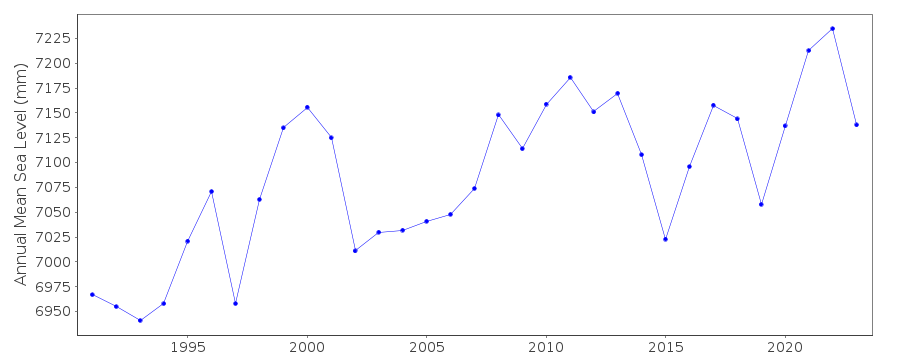
| Time span of RLR data: | 1991 – 2025 |
| RLR completeness (%): | 100 |
| Time span of metric data: | 1959 – 2025 |
| Metric completeness (%): | 94 |
| Link to ellipsoid: | Available |
| Date of last update: | 01 Jun 2026 |
| Green Arrow: | Current Station |
| Yellow Marker: | Neighbouring RLR Station |
| Red Marker: | Neighbouring Metric Station |
Please note: In many cases, the station position in our database is accurate to only one minute. Thus, the tide gauge may not appear to be on the coast.
Tide Gauge Data
Additional Data Sources (guide to additional data sources)
Nearby GNSS Stations from SONEL: 01NA, DWNI, 02NA, 00NA, LKYA, DARMNearby Real Time Stations from VLIZ: darw
Fast Delivery Data from UHSLC station 168: hourly and daily
Research Quality Data from UHSLC station 168: hourly and daily
Station Documentation
Link to RLR information.Documentation added 1995-05-02
Station density along some sections of the Australian coast has meant that station codes 601 onwards have been re-ordered compared to those in earlier versions of the PSMSL data set.Documentation added 1996-03-28
Revised data received from the National Tidal Centre, Bureau of Meteorology, South Australia SEAFRAME station installed 18/05/1990. Darwin is a cooperative station between NTF and NOAA/NOSDocumentation added 1998-01-20
Prior to 1993: gauge type= Leupold Stevens A71 float/wellDocumentation added 2000-04-10
This is a "baseline station" of the Australian National Tidal Facility.Documentation added 2000-04-10
Darwin 680/011 RLR(1996) is 13.335m below BM 70/8Documentation added 2010-09-15
New benchmark information received from National Tidal Centre and Geoscience Australia. RLR (1996) now defined as 35.517 m below NTS302 NM/G/21 491.Documentation added 2011-10-19
From information from both the National Tidal Centre and Geoscience Australia it seems that the datum reference for Darwin from the 2010 data has changed from Tide Gauge Zero (TGZ) to Lowest Astronomical Tide (LAT). LAT is 0.13m below TGZ which means that for benchmark BM 4566 previous reference 10.349m above TGZ is now 10.479m above LAT. The RLR factor has been adjusted to accommodate the change from 3.0m to 2.87m.Data Authority
National Tidal CentreBureau of Meteorology
PO Box 421
Kent Town 5071
South Australia
Documentation added 2010-08-12
Formerly known as the National Tidal Facility

![]()
![]()
![]()
