Links
Donate
Donate to PSMSL
The UK South Atlantic Sea Level Network
The UK South Atlantic sea level network consists of tide gauges of various kinds at South Atlantic islands, Gibraltar and stations in Antarctica.
The network originated from a National Oceanography Centre research programme called ACCLAIM (Antarctic Circumpolar Current Levels by Altimetry and Island Measurements) that was a national contribution to the World Ocean Circulation Experiment (WOCE). For a history of the development of ACCLAIM see:
Spencer, R., Foden, P.R., McGarry, C., Harrison, A.J., Vassie, J.M., Baker, T.F., Smithson, M.J., Harangozo, S.A. and Woodworth, P.L. 1993. The ACCLAIM programme in the South Atlantic and Southern Oceans. International Hydrographic Review, 70, 7-21.
The UK South Atlantic sea level network forms part of the UK's commitment to the Global Sea Level Observing System (GLOSS) of the Intergovernmental Oceanographic Commission (IOC), the other part of that commitment being gauges in the UK itself.
The main NOC principal investigators involved in this activity are Angela Hibbert, Philip Woodworth, Peter Foden, and Jeff Pugh.
South Atlantic Data Sets
Phase 1 Coastal Gauges
In Phase 1 from 1983, measurements at coastal tide gauge sites took the form of sub-surface pressure (SSP) measurements (units of pressure e.g. mbar) rather than sea level (units of length e.g. centimetres). SSP is here defined as the total, measured pressure recorded by a sub-surface pressure transducer, a measurement which includes the pressure load from the atmosphere as well as from the water column. It is absolutely essential that any user of these data realises which data type (either SSP or sea level) is being analysed.
The Phase 1 coastal SSP data were acquired in different ways (e.g. with a diver-replaced Aanderaa pressure gauge at Ascension, or with a Digiquartz in the sea sensor at St.Helena, see Spencer et al. 1993 for details) and with different pressure integration periods (e.g. quarter hour, half hour, one hour). For some data sets, the original data have been filtered to give one hour sampling. However, common to all records is an uncertainty connected with potential offset biases and drifts in the pressure sensors. The drifts mean that in most cases the records should not be used, without further careful attention in particular studies, for the study of timescales seasonal or longer.
Phase 2 Coastal Gauges
From around early 1993, the gauges at several sites were replaced by 'B gauges' which record SSP, air pressure and sea level as described in:
Woodworth, P.L., Vassie, J.M., Spencer, R. and Smith, D.E. 1996. Precise datum control for pressure tide gauges. Marine Geodesy, 19(1), 1-20.
These gauges have precise datum control and are used to provide long term sea level change data to the PSMSL.
More recently, radar tide gauges delivering data to a known datum have been used to provide sea level data that have also been contributed to the PSMSL.
Phase_1_Radar Coastal Gauges
These sets of sea level data were obtained by radar gauges which we believe can be considered as providing a continuous time series to the same datum (as we have no reason to believe that the radar information contains an instrumental drift), but for which we do not know the actual datum with respect to land benchmarks, as required for Phase 2 data.
It is possible that eventually some of the Phase_1_Radar data may be 'promoted' to Phase 2 when additional datum information (e.g. as provided by simultaneous tide pole measurements) become available.
Some Phase 1, some Phase_1_Radar and all Phase 2 coastal data will contain ancillary information on air pressures and sea temperatures from various sensors.
UK South Atlantic Gauges

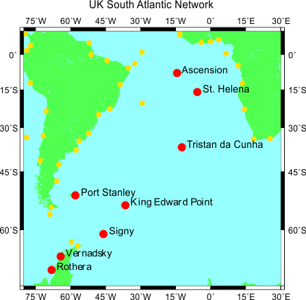
Red dots on the above map indicate sites of the UK South Atlantic coastal tide gauge network, while the yellow dots show gauges (not necessarily operational) committed to the GLOSS programme by other countries in the region. Gibraltar (off the map to the north) is also part of this network.
Data Sets
To obtain data from these sites, jump to:
https://ntslf.org/files/acclaimdata
which will contain three sub-directories of data:
- 'phase1', which contains data collected by Phase 1 sensors
- 'phase2', which contains data collected by Phase 2 sensors, and
- 'phase_1_radar', which contains data collected by Phase_1_Radar sensors.
In addition, it contains a file 'readme.formats' which describes the formats of data files.
Each of the three sub-directories contains a file INVENTORY which summarises the data holdings and provides short documentation. All data sets have been quality controlled.
Further Information
For further information, please contact Dr. Angela Hibbert.
Contact address and numbers:
National Oceanography Centre
Joseph Proudman Building
6 Brownlow Street
Liverpool L3 5DA
United Kingdom
Telephone: +44 (0)151-795-4800
Fax: +44 (0)151-795-4801


