Data
- Obtaining
- Supplying
- High-Frequency
- Bottom Pressure Records
- Other Long Records
- GLOSS/ODINAFRICA Calibration Data
Donate
Donate to PSMSL
Other Links
Information
| Latitude: | -23.3010 |
| Longitude: | -168.2910 |
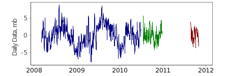
| Start of first deployment: | 2008-02-11 |
| End of last deployment: | 2011-12-16 |
| Ocean region: | 2.3 |
| Green arrow: | Current Bottom Pressure Location |
| Yellow Marker: | Other Bottom Pressure Location |
Deployments (best channel from each deployment)
Go to page with all data from this deployment.| Start | End | Latitude | Longitude | Depth | Data | Metadata |
|---|---|---|---|---|---|---|
| 2008-02-11 | 2010-06-29 | -23.301 | -168.291 | 5659 | 51426_0810: Hourly, Daily, Tide | Metadata |
| 2010-07-17 | 2010-12-25 | -23.301 | -168.291 | 5659 | 51426_1010: Hourly, Daily, Tide | Metadata |
| 2011-08-23 | 2011-12-16 | -23.301 | -168.291 | 5659 | 51426_1111: Hourly, Daily, Tide | Metadata |
Suppliers:
NOAA National Data Buoy Center
Building 3205
Stennis Space Center, MS 39529
228-688-2805
USA


