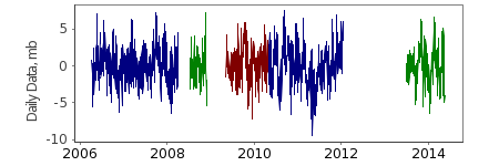
NDBC 41421 - North St Thomas - 300 NM N of St Thomas, Virgin Is
Information
| Latitude: |
23.4090 |
| Longitude: |
-63.9060 |
| Start of first deployment: |
2006-04-11 |
| End of last deployment: |
2014-05-18 |
| Ocean region: |
1.3 |
| Green arrow: |
Current Bottom Pressure Location |
| Yellow Marker: |
Other Bottom Pressure Location |
Deployments (best channel from each deployment)
Go to page with all data from this deployment.
| Start |
End |
Latitude |
Longitude |
Depth |
Data |
Metadata |
| 2006-04-11 | 2008-04-03 | 23.409 | -63.906 | 5845 | 41421_0608: Hourly, Daily, Tide
| Metadata
|
| 2008-07-13 | 2008-11-30 | 23.409 | -63.906 | 5845 | 41421_0809: Hourly, Daily, Tide
| Metadata
|
| 2009-05-11 | 2010-05-02 | 23.409 | -63.906 | 5845 | 41421_0910: Hourly, Daily, Tide
| Metadata
|
| 2010-05-03 | 2012-01-16 | 23.409 | -63.906 | 5845 | 41421_1012: Hourly, Daily, Tide
| Metadata
|
| 2013-07-01 | 2014-05-18 | 23.409 | -63.906 | 5845 | 41421_1314: Hourly, Daily, Tide
| Metadata
|
Suppliers:
NOAA National Data Buoy Center
Building 3205
Stennis Space Center, MS 39529
228-688-2805
USA


