Data
- Obtaining
- Supplying
- High-Frequency
- Bottom Pressure Records
- Other Long Records
- GLOSS/ODINAFRICA Calibration Data
Donate
Donate to PSMSL
Other Links
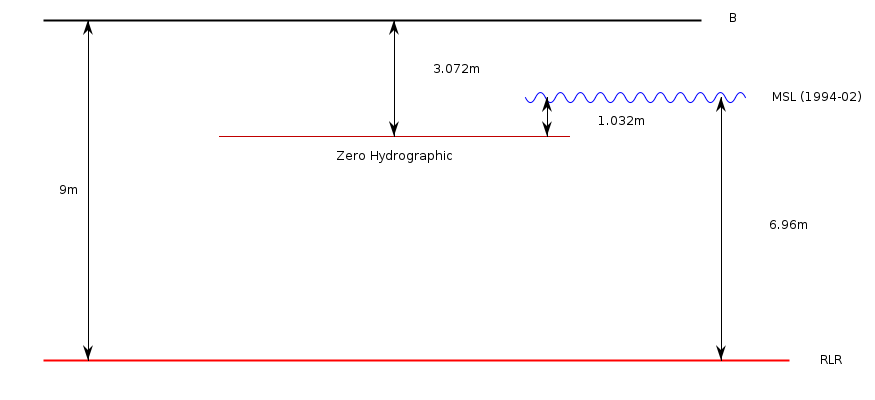
Revised Local Reference (RLR) Diagram for KERGUELEN
Station ID: 1849

If the image above appears blurry, or you would like to see a larger image, please view the full-sized image of the RLR diagram.
Datum information
Add 5.928m to all data values to refer to RLR
RLR is 9.000m below primary benchmark B
Ellipsoidal information from SONEL (explanation)
| GNSS | Solution | Height | Velocity | Epoch | GNSS Start | GNSS End | Distance |
|---|---|---|---|---|---|---|---|
| KERG | JPL14 | 32.172 ± 0.004 | 0.69 ± 0.31 | 2020.0000 | 1994-11-16 | 2023-03-23 | 4 |
| KERG | NGL14 | 32.173 ± 0.005 | 0.14 ± 0.59 | 2020.0000 | 1994-11-16 | 2023-03-23 | 4 |
| KETG | NGL14 | 30.982 ± 0.004 | Not robust | 2020.0000 | 2003-12-15 | 2023-03-23 | 2723 |
| KETG | ULR7a | 30.974 ± 0.002 | -0.50 ± 0.44 | 2020.9932 | 2003-12-15 | 2023-03-23 | 2723 |
| KERG | ULR7a | 32.159 ± 0.007 | -0.56 ± 0.28 | 2020.0000 | 1994-11-16 | 2023-03-23 | 4 |
| KERG | GT3 | 32.176 ± 0.008 | 0.05 ± 0.30 | 2020.0000 | 1994-11-16 | 2023-03-23 | 4 |


