Data
- Obtaining
- Supplying
- High-Frequency
- Bottom Pressure Records
- Other Long Records
- GLOSS/ODINAFRICA Calibration Data
Donate
Donate to PSMSL
Mean Sea Level Data
Further Information
Ellipsoidal Links for RLR Data
The monthly sea level records that the PSMSL distribute are heights above a local datum. As a result, heights from one station cannot be compared with other records unless we know the difference in height between the two datums. For our RLR data set, the stability of the local station datum is ensured by fixing its height to a geodetic benchmark assumed to be on reasonably stable ground. The measurements taken from tide gauges in this way are known as relative mean sea level: height is measured relative to the local land. As a result, our data can be affected by vertical movement of the land.
For some analyses, we may wish to attempt to remove the land movement signal from the tide gauge record. For example, if we are attempting to construct a reconstruction of historical global mean sea level from PSMSL records. we need to remove the local land movement from each site before attempting to combine them into a global record.
In other cases, we may require sea level heights to be expressed with respect to an Earth-centred ellipsoid: for example, if we wish to compare sea level measured by tide gauges with sea level measured by satellite altimetry. In this case, we need to know the height difference between the local tide gauge datum and the reference ellipsoid used.
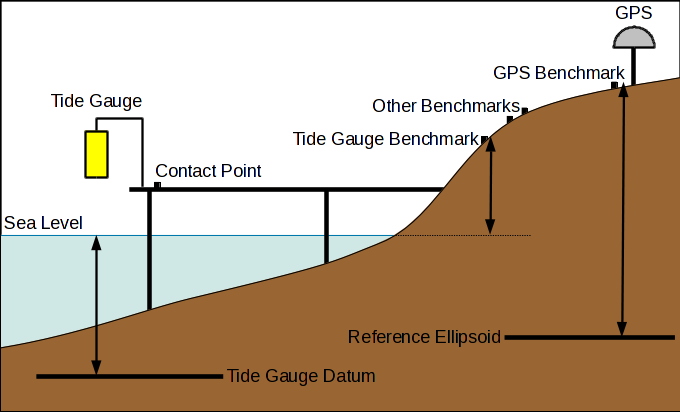
We can try and solve both of these cases by using continuous GNSS measurements from a receiver located near the tide gauge. The sketch below illustrates a typical tide gauge installation. The GNSS receiver measures heights relative to an ellipsoid, and can be used to estimate the rate of vertical movement of the local land mass. The tide gauge datum can be associated with these estimates if routine geodetic levelling campaigns are carried out between the tide gauge benchmark and the GNSS receiver.
PSMSL have been working in collaboration with colleagues at SONEL, the GLOSS data centre for GNSS measurements, to make it easier to connect PSMSL RLR data with SONEL's GNSS data. Where a link to a GNSS receiver can be established, on PSMSL's station page (e.g. the station page for Newlyn), the station information section will note that a link to the ellipsoid is available.
Information Available
Details of the links are provided in the "Ellipsoidal information" section of a station's RLR diagram page (e.g. the RLR diagram page for Newlyn), along with the page listing all sites where links to the ellipsoid have been made. These contain the following information:
- The GNSS receiver used to produce the estimate, referred to by its four character station id, and a link to the data from SONEL.
- The GNSS solution used to compute the numbers.
- The estimated height of our RLR datum above the ellipsoid, and the uncertainty in this measuremnt.
- The estimated linear rate of vertical land movement measured by the GNSS receiver: positive numbers imply the land is rising, negative numbers imply sinking. The uncertainty is also included. In some cases a robust estimation could not be obtained.
- The epoch: the date at which the estimation of height is made.
- The start and end dates of the data available for this GNSS receiver at SONEL
- The distance between the tide gauge and the GNSS receiver. Note the accuracy of this value will depend of the accuracy of our tide gauge location, which varies considerably between suppliers.
Currently, all solutions provided use ITRF2014, and hence GRS80 as the reference ellipsoid, but this may change in the future.
Full list of stations with ellipsoidal links
A comprehensive list of all available links are available here.

![]()
![]()
![]()
