Data
- Obtaining
- Supplying
- High-Frequency
- Bottom Pressure Records
- Other Long Records
- GLOSS/ODINAFRICA Calibration Data
Donate
Donate to PSMSL
Data Notes
- Individual Station Data and Plot Notes
- Referencing the Data Set
- PSMSL Help File
- 2010 Changes to the PSMSL Data Files
Extracted from Database
13 Jul 2026
Station Information
| Station ID: | 484 |
| Latitude: | 43.3686 |
| Longitude: | -8.39775 |
| GLOSS ID: | 243 |
| Coastline code: | 200 |
| Station code: | 30 |
| Country: | SPAIN |
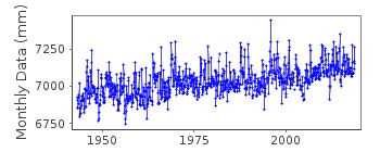
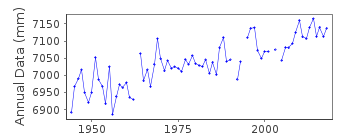
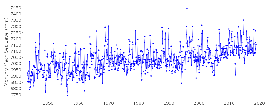
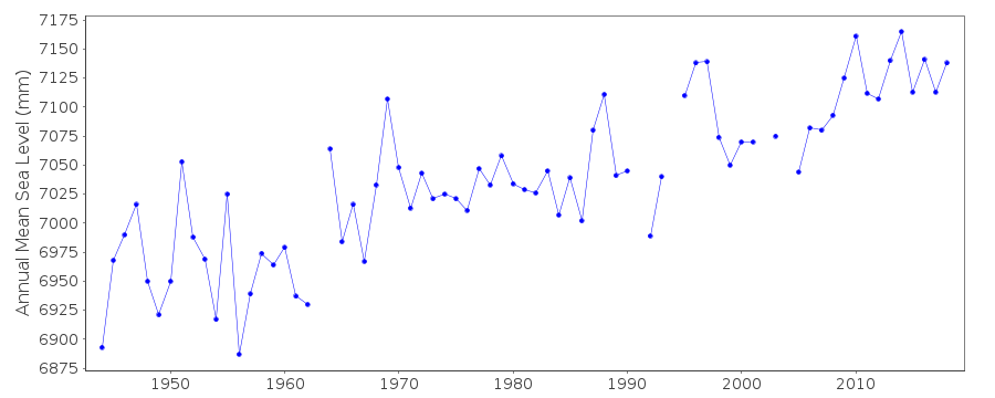
| Time span of data: | 1943 – 2018 |
| Completeness (%): | 98 |
| Link to ellipsoid: | Available |
| Date of last update: | 05 Mar 2019 |
| Green Arrow: | Current Station |
| Yellow Marker: | Neighbouring RLR Station |
| Red Marker: | Neighbouring Metric Station |
Please note: In many cases, the station position in our database is accurate to only one minute. Thus, the tide gauge may not appear to be on the coast.
Tide Gauge Data
Additional Data Sources (guide to additional data sources)
Nearby GNSS Stations from SONEL: ACORNearby Real Time Stations from VLIZ: cor2
Fast Delivery Data from UHSLC station 830: hourly and daily
Research Quality Data from UHSLC station 830: hourly and daily
Station Documentation
Link to RLR information.Documentation added 2001-10-15
La Coruna I 200/030 RLR(1962) is 10.14m below BM NAPG 467Documentation added 2005-05-23
A paper by Marcos et al (JGR Volume 11, 2005) provides an overview of the tide gauge records on the northern coast of Spain.Documentation added 2011-10-25
The IEO have revised the data for Coruna for 1943-1963. These revised data values have replaced the previous data values.Documentation added 2014-09-03
Using a values from a listing recently supplied by IEO the co-ordinates for Coruna have been revised.Data Authority
Instituto Español de OceanografíaCorazón de María, 8
28002, Madrid

![]()
![]()
![]()
