Global Sea Level Observing System (GLOSS)
What is GLOSS?
The Global Sea Level Observing System (GLOSS) was established by the Intergovernmental Oceanographic Commission (IOC) of UNESCO in 1985 to establish a well-designed, high-quality in situ sea level observing network to support a broad research and operational user base.
GLOSS provides oversight and coordination for global and regional sea level networks in support of, and with direction from, the oceanographic and climate research communities. GLOSS remains under the auspices of the IOC and is one of the observing components under the World Meteorological Organisation (WMO) / IOC Joint Technical Commission for Oceanography and Marine Meteorology (JCOMM). GLOSS relies on the participation of tide gauge operators to maintain tide gauges stations to a research quality standard. At present about 80 nations participate in the GLOSS programme.
GLOSS contributes to the Global Ocean Observing System (GOOS), particularly its climate, coastal and operational service modules, through the progressive development of the sea level measurement network, data exchange and collection systems, and preparation of sea level products for various user groups.
For a complete description of the GLOSS program, see the latest GLOSS Implementation Plan.

The GLOSS Core Network (GCN)
Various tide gauge networks have contributed to GLOSS, each with a different focus and each changing over time as research priorities evolve. The main component is the GLOSS Core Network (GCN), a global set of ~300 tide gauges that serves as the backbone of the global in situ sea level network.GCN gauges were allocated to each island or group of islands at intervals not closer than 500 km, and along continental coasts at intervals generally not less than 1000 km. Preference was given to islands in order to maximise exposure to the open ocean.
Maps showing the status of the data streams from each GCN station can be found on the PSMSL website here: status maps.
A list of the GCN stations can be found here, and the locations of the current GCN are shown in the figure below. The various GLOSS data centres provide different types of data for each station with different resolutions and levels of quality-control. A good place to start is the GLOSS Station Handbook, where clicking on a particular station and following the link to the station page will provide links to the different time series available for that station.
The GLOSS Core Network (GCN) [defined as GLOSS 2010]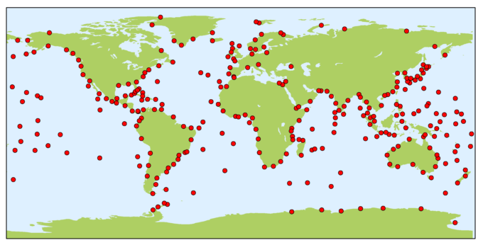
Role of the PSMSL
Established in 1933, the Permanent Service for Mean Sea Level (PSMSL) is responsible for the collection, publication, analysis and interpretation of sea level data from the global network of tide gauges, including the GLOSS Core Network. It is based in Liverpool at the National Oceanography Centre (NOC). PSMSL generally relies on Member Nations to provide the final version of the monthly time series with all quality control assessments applied and documented. Where possible, in order to construct time series of sea level measurements at each station, the monthly and annual means are reduced to a common datum. This reduction is performed by the PSMSL making use of the tide gauge datum history provided by the supplying authority. The PSMSL archive comprises of ‘delayed-mode’ monthly mean sea level values most suitable for studies of long-term sea-level change; most studies of 20th century global sea level rise are based on the PSMSL data set.
Other data centres
GLOSS is a global endeavour requiring the coordinated participation of an international group of agencies. The following data centres provide complimentary GLOSS data streams while helping to shape the future of the global in situ sea level observing network. In general, GLOSS data centres are associated with scientists involved with sea level research, which helps to maximise the quality of GLOSS datasets.
British Oceanographic Data Centre (BODC)
 The GLOSS Delayed Mode Data Centre is operated by the BODC in collaboration
with PSMSL. It has the responsibility for assembling, quality controlling and
distributing the “final” version of GLOSS sea-level data sets, as well as all
supporting metadata information (including benchmark details). The Delayed Mode
Centre handles hourly (or
sub-hourly) values, together with ancillary variables (e.g. atmospheric
pressure) where these are available, from the GCN, GLOSS-LTT, and GLOSS-OC
databases. It generally relies on Member Nations to provide the final
version of the hourly (or sub-hourly) time series with all quality control
assessments applied and documented. The Delayed Mode Centre will, on request from
member nations, form and provide the PSMSL with monthly averages based on the
final data sets received.
The GLOSS Delayed Mode Data Centre is operated by the BODC in collaboration
with PSMSL. It has the responsibility for assembling, quality controlling and
distributing the “final” version of GLOSS sea-level data sets, as well as all
supporting metadata information (including benchmark details). The Delayed Mode
Centre handles hourly (or
sub-hourly) values, together with ancillary variables (e.g. atmospheric
pressure) where these are available, from the GCN, GLOSS-LTT, and GLOSS-OC
databases. It generally relies on Member Nations to provide the final
version of the hourly (or sub-hourly) time series with all quality control
assessments applied and documented. The Delayed Mode Centre will, on request from
member nations, form and provide the PSMSL with monthly averages based on the
final data sets received.
University of Hawaii Sea Level Center (UHSLC)
 The UHSLC operates the GLOSS Fast-Delivery Center, which is responsible for assembling and distributing a version of GLOSS sea level data that has undergone preliminary quality control by Member Nations and includes supporting metadata information. “Fast-Delivery” implies posting of the data within 1-2 months. The UHSLC provides Fast-Delivery quality control services for Member States that do not have that capability. The Joint Archive for Sea Level (JASL) hosted by the UHSLC acquires hourly datasets from GLOSS and non-GLOSS tide gauges from around the world that have received a final quality assessment from the data originators. JASL provides an independent check of the data, primarily to identify any remaining outliers, timing issues, or datum shifts. Any quality issues with the data are brought to the attention of the data originators for reconciliation. JASL then assembles a single hourly time series for each station, or a series of sub-records if datum changes occur over time. The JASL dataset therefore represents a “data product”, as problematic data points are not simply flagged and left in the records as they are by BODC for the GLOSS Delayed Mode Dataset, but changes to the data actually are implemented by JASL analysts (e.g., level adjustments, timing shifts, outlier removal). These changes are documented in the metadata information.
IOC Sea Level Station Monitoring Facility
 The Flanders Marine Institute (VLIZ, Belgium) hosts a Sea-Level Station Monitoring Facility that includes GLOSS Core stations. VLIZ provides a web-based global sea-level station monitoring service for viewing sea-level data received in real-time from different network operators primarily via the GTS, but also through other communications channels. The service provides information about the operational status of GLOSS stations through quick inspection of the raw data stream. The sea-level station monitoring system also runs a web-service for direct data access. The sea-level station catalogue system developed and maintained at VLIZ links sea-level station metadata repositories.
Système d’Observation du Niveau des Eaux Littorales (SONEL)
 SONEL is the dedicated centre for Global Navigation Satellite System (GNSS) data
at or near tide gauge stations. This data is essential for studies of sea level
change, as it provides information about how the tide gauge is moving in
three-dimensional space. The vertical movement of the gauge will register as
local sea level change, but these changes are not related to the height of the
ocean surface. SONEL is supported by the University of La Rochelle and the
French CNRS/INSU institute. SONEL provides information about the status of
GNSS stations at or nearby tide gauges through a web-based monitoring facility.
It assembles, archives, and distributes GNSS observations and metadata that can
be accessed through the web-based facility, as well as anonymous FTP server.
SONEL is the dedicated centre for Global Navigation Satellite System (GNSS) data
at or near tide gauge stations. This data is essential for studies of sea level
change, as it provides information about how the tide gauge is moving in
three-dimensional space. The vertical movement of the gauge will register as
local sea level change, but these changes are not related to the height of the
ocean surface. SONEL is supported by the University of La Rochelle and the
French CNRS/INSU institute. SONEL provides information about the status of
GNSS stations at or nearby tide gauges through a web-based monitoring facility.
It assembles, archives, and distributes GNSS observations and metadata that can
be accessed through the web-based facility, as well as anonymous FTP server.

![]()
![]()
![]()
