Data
- Obtaining
- Supplying
- High-Frequency
- Bottom Pressure Records
- Other Long Records
- GLOSS/ODINAFRICA Calibration Data
Donate
Donate to PSMSL
Other Links
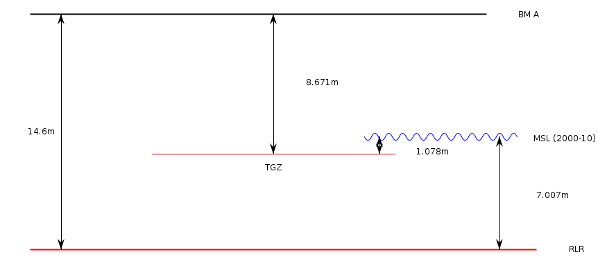
Revised Local Reference (RLR) Diagram for DAKAR 2
Station ID: 1816

If the image above appears blurry, or you would like to see a larger image, please view the full-sized image of the RLR diagram.
Datum information
Add 5.929m to all data values to refer to RLR
RLR is 14.600m below primary benchmark BM A
Ellipsoidal information from SONEL (explanation)
| GNSS | Solution | Height | Velocity | Epoch | GNSS Start | GNSS End | Distance |
|---|---|---|---|---|---|---|---|
| DAKR | ULR7a | 23.825 ± 0.009 | -0.60 ± 0.43 | 2020.0000 | 2011-08-12 | 2021-01-20 | 4847 |
| DAKA | NGL14 | 23.872 ± 0.004 | Not robust | 2007.4305 | 2002-03-21 | 2007-06-08 | 5213 |
| DAKR | JPL14 | 23.828 ± 0.005 | -0.49 ± 0.42 | 2020.0000 | 2011-08-12 | 2021-01-20 | 4847 |
| DAKA | JPL14 | 23.861 ± 0.010 | Not robust | 2020.0000 | 2002-03-21 | 2007-06-08 | 5213 |
| DAKA | GT3 | 23.874 ± 0.004 | Not robust | 2007.4315 | 2002-03-21 | 2007-06-08 | 5213 |
| DAKR | NGL14 | 23.827 ± 0.006 | -1.10 ± 0.68 | 2020.0000 | 2011-08-12 | 2021-01-20 | 4847 |


